Virginia’s Coast and Flood Control – The Past Is Prologue

by James C. Sherlock
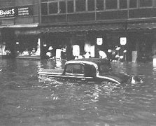
Granby Street Norfolk after Great Hurricane of 1933

So how do we picture how bad a hurricane or Nor’easter could be along Virginia’s coast? What might it look like?

Won’t the Outer Banks catch the worst of any hurricane and break it up?

Well, no.

Consider some stunning historical examples.

The storms of the Eighteenth Century

The entire 18th century was replete with storms that ravaged the Virginia coast and rivers that drain into the Chesapeake.

Twenty six of them. Read about them.

Astonishing stories.

In one, you will read that on October 16, 1781:

“A storm of “unknown character” struck Virginia. The Earl of Cornwallis, at Yorktown, was trapped by the French Fleet and the Patriot Army, under the command of George Washington. The Earl decided to flee to the north to Gloucester Point under the cover of darkness. A “furious storm” doomed the plan to failure, as seas ran high and every boat was “swamped.” He sent forward his flag of truce and surrendered, thus ending the battle.”

In another:

“September 22-24, 1785: The “most tremendous gale of wind known in this country” passed over the Lower Chesapeake Bay and went along a track very similar to the Chesapeake-Potomac Hurricane of 1933. At Norfolk, lower stories of dwellings were flooded. Warehouses were totally carried away by the storm surge, causing large amounts of salt, sugar, corn, and lumber to disappear. A large number of cattle drowned, and people hung onto trees for dear life during the tempest. At Portsmouth, the entire town was submerged.

Forrest’s book, Sketches of Norfolk, offers this account of the storm: “This year, 1785, was noted for the highest tide ever before known to Norfolk, completely deluging a large portion of its site on the water side.”

Almost all ships in the area were driven from their moorings near Norfolk. Many ships were dismasted as well. The brig Nancy, coming from Madeira with a cargo of wine, was dashed to pieces on the Virginia Capes. Only two aboard survived the ordeal. The sloop Phoebe lost its bowsprit and was laid upon her beam ends. A Dutch ship was found fully loaded, with no one aboard. Vessels floated inland into cornfields and wooded areas. No less than 30 vessels were seen beached after the storm. Damages totaled £30,000. At least two died due to shipping disasters. After ravaging Virginia, the system tracked up the coast to Boston.“

Willoughby Spit and the Hurricane of 1749

A fierce hurricane in 1749 drove the water in the Chesapeake to rise to 15 feet above normal.

It destroyed Ft. George located at or near the site of what is now Ft. Monroe. A large airborne tree and its root ball breached the outer wall of the fort on the land side. Water breached and destroyed both the outer and inner walls of the fort on the Bay side.

It was so strong that it formed Willoughby Spit, the eastern terminus of the Hampton Roads Bridge Tunnel just north of the Naval Base Norfolk.

Bodies from shipwrecks washed ashore for days.
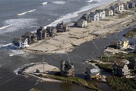
Willoughby Spit after Isabel

In 2003, Hurricane Isabel tried to take Willoughby Spit back. Isabel destroyed the protective beach berm, nearly three quarters of the protective sand dune, and several dwellings. The Corps of Engineers Willoughby And Vicinity Storm Damage Reduction Project, the largest single storm damage reduction project in the City of Norfolk, was completed in 2017.

We literally can’t withstand another century of storms like the 18th without modern flood protection systems.

The Great Chesapeake-Potomac Hurricane of 1933
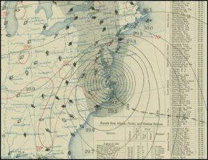
Surface map for August 23rd, 1933 at 8 AM, EST

The worst storm in the past 100 years was the Great Chesapeake-Potomac Hurricane of 1933.It was a killer.

As with so many storms, it wasn’t the strength of the 1933 winds so much as the path of the eye that caused the widespread damage. The eye passed directly over Norfolk, moved north along the Chesapeake and veered slightly inland up the Rappahannock and crossed the Potomac River near Colonial Beach.

It caused nearly 10 feet of storm surge at Norfolk’s Sewell’s Point. The highest point in Norfolk is the runways of the airport at 12 ft.

Four feet of flooding along the York River.
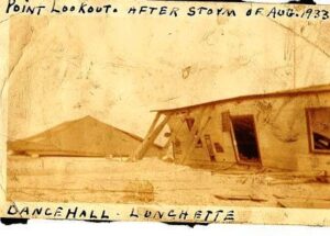
Point Lookout at the mouth of the Ware River after 1933 hurricane

The storm inundated all the low lying areas along the Potomac. Eight feet of flooding along U.S. 1. in Alexandria. It knocked a train off of the Anacostia River bridge in D.C. Created an inlet that turned Assateague into an island.

Thirteen inches of rain and 47 bridges destroyed in York County Pennsylvania.

That sort of thing.

Bottom line

Widespread destruction and loss of life along Virginia’s coasts and rivers is not theoretical. It is assured if we don’t take action to protect ourselves.       As shown by the 18th-century storms, no argument over climate change is relevant.

The Commonwealth, as described in yesterday’s column, is on the wrong track entirely.

Perhaps the Department of Conservation and Recreation can be sobered by this recounting of our history with storms.

But I doubt it will matter.

Even sober they have no idea what they are doing.


Share this article


ADVERTISEMENT

(comments below)


ADVERTISEMENT

(comments below)


Comments

27 responses to “Virginia’s Coast and Flood Control – The Past Is Prologue”

  1. Nancy Naive Avatar
    Nancy Naive

    I got a ton of room between me and high water (20+ feet). It’s the 20, or so, 75′ oaks that bother me. I ain’t gonna get it from the bottom, but we did see an oak cut a neighbor’s house from the roof ridge to the foundation.

  2. Nancy Naive Avatar
    Nancy Naive

    “Wait! I thought you said, ‘Build your house on weak and shifting sands,’ although it did seem kinda stupid now that I think about it.”

  3. Peter Galuszka Avatar
    Peter Galuszka

    IN 1954, when I was 18 months old, my father, a Navy officer, was transferred from Philadelphia Naval Hospital, where I was born, to Camp Lejeune, N.C. Our quarters weren’t ready so my family rented a beach house at Topsail Island. The quarters were then ready and we moved. Hurricane Hazel showed up ravaged the NC coast. My parents drove out the beach house and couldn’t find one board. I was too young to remember anything of this.

    1. Nancy Naive Avatar
      Nancy Naive

      We were in Norfolk for Hazel. I remember flooded streets and playing in the water. A small tree fell across the road, and some of the men righted it, somewhat. In 1968 when we came back to the area, the tree was another 20′ taller and still leaning.

  4. It was foolish for anyone to have built anything on Willoughby Spit. While I do not wish to see physical harm come to anyone, I cannot generate much sympathy for those whose property there is damaged or destroyed by storms. I do not think structures on the Spit which are lost to storms should be rebuilt.

    In my opinion, the Willoughby And Vicinity Storm Damage Reduction Project should have consisted of buying up all the property on Willoughby Spit, razing every structure and maybe turning the land into a public park with limited amenities, until a future storm comes to take it away.

    At least I-64 / HRBT is designed to remain in place when Willoughby Spit is gone, or so I’ve been told.

    1. Stephen Haner Avatar
      Stephen Haner

      The 1900 Galveston storm, referred to as “Isaac’s Storm” in a recent (excellent) book, remains the worst in U.S. history for human deaths. Agreed, all those barrier islands were created by storms, will be wiped out one day by storms, and people who build there should not be insured….but as long as they are, we’ll go back in the summers. 🙂

    2. Nancy Naive Avatar
      Nancy Naive

      There’s a section of a couple hundred yards actually touching on the spit. Might take a couple of months to join the two bridges.

      Meh, at worst the HRBT becomes an artifical reef.

    3. James C. Sherlock Avatar
      James C. Sherlock

      Not exactly clear from the picture what will be left of I-64 at the east end of the Hampton Roads Bridge Tunnel if Willoughby Spit is gone, but I’ll take their word for it. https://uploads.disquscdn.com/images/3c59243478583fb24ccf906681c583d2b80859c4f36d94f2014236774757e96e.jpg

      1. I have been told by people who should know that the portions of I-64 which cross Willoughby Spit are constructed on pilings as deep as those used for the bridge portions of the highway. Essentially, it is part of the bridge and is capable of supporting itself if the land beneath it is gone. This is what I have been told, although I admit I have never seen construction drawings.

        Assuming it is true, though, if you air-brush water into that photo over the land mass, leaving the highway in place, you’d have a pretty good idea what things would look like if a storm takes the Spit. Of course, a strong enough storm could take everything including the highway and HRBT.

        If what I have heard about the road’s construction is not true, then see Nancy Naive’s comment, above. 😉

        1. James C. Sherlock Avatar
          James C. Sherlock

          I tend to trust VDOT on that. They are capable builders.

          Sometimes hard headed, though. They fought the Corps of Engineers for years for a permit for Rt. 460 and lost.

          Big mistake, and a very expensive one, but not a civil engineering mistake.

          The Corps is the Clean Water Act regulator. VDOT should have taken the hint years earlier.

  5. DJRippert Avatar

    “The eye passed directly over Norfolk, moved north along the Chesapeake and veered slightly inland up the Rappahannock and crossed the Potomac River near Chesapeake Beach.”

    Did you mean Colonial Beach?

    The only Chesapeake Beach I know is in Maryland on the western shore of the Chesapeake Bay directly across from the mouth of the Choptank River. The Patuxent River is pretty close but the Potomac is a pretty good hike away.

    Is there another Chesapeake Beach?

    1. James C. Sherlock Avatar
      James C. Sherlock

      Good catch. I’ll fix it.

    2. There is another Chesapeake Beach, although it’s nowhere near the Potomac River either.

      It’s also not a town. In the City of Virginia Beach, the beach on the Chesapeake Bay which is bisected by the Chesapeake Bay Bridge Tunnel is named Chesapeake Beach. It’s also known locally as “Chic’s Beach”.

      1. James C. Sherlock Avatar
        James C. Sherlock

        Known locally as SEALs beach.

        1. THE best seafood restaurant in Va Beach used to be adjacent to that beach: The Duck-Inn.

          Unfortunately, it closed in 2005 because the land became too valuable to allow a “seafood shack” to be profitable (taxes, taxes, taxes). I think there is a condo development there now. Good Lord but they had good crab cakes – and the best hushpuppies I’ve ever eaten.

          1. James C. Sherlock Avatar
            James C. Sherlock

            It is not a totally sad story. The last family member that inherited Duck Inn was a faculty member at Norfolk Academy. He sold the land for more money that he could count.

  6. Thanks for the history lesson. Most of us know nothing of extreme weather events that occurred before our own lifetimes and memories.

    As to the larger point of your series, Virginia needs to protect itself through hardened infrastructure as well as natural systems. Both. Most likely, it will take a Katrina-scale disaster to get us off our bets.

    1. James C. Sherlock Avatar
      James C. Sherlock

      As I mentioned in my first column in this series, the gentle souls at DCR think they invented natural systems.

      One sign among many that they don’t have any idea what they are doing is that the Corps of Engineers is tasked by federal law to exhaust natural systems – green measures – before they build the first “castle” – engineered solution.

      DCR is starting so far behind reality that they won’t ever figure out what they have to do to succeed – or even how to define success.

  7. Nancy Naive Avatar
    Nancy Naive

    FWIW, started to Hampton today. I64 is closed. Cops everywhere. Alll surface roads were effed up with 20 minutes to go 3 blocks.

    VDOT 511 said everything was a go. Had green lines on all roads. Worthless POS.

    Wavy10 said Kamala was here to visit HU. Damn woman! Even Trump didn’t screw it up this bad when he came.

    1. how_it_works Avatar
      how_it_works

      Several years ago VA 28 was shut down due to an accident and VDOT’s 511, nearly 30 minutes after the accident, had no information about a road closure on 28.

      1. Nancy Naive Avatar
        Nancy Naive

        What I don’t get is if the local news stations can get it immediately for the whole state, why doesn’t VDOT511 just redirect.

        BTW, Google showed it green too, but then without cellphone data, they assumed it was running.

        1. DJRippert Avatar

          Use Waze.

    2. James C. Sherlock Avatar
      James C. Sherlock

      The Secret Service can get a bit full of themselves.

      1. Nancy Naive Avatar
        Nancy Naive

        Ya think? It took me awhile to figure the patterns. All overpasses crossing I64 were closed completely. Only roads that underpass the interstate were open, and of course, all entrances to the interstate were closed.

        I suspect the Secret Deodorant guys thought someone might stop on an overpass and throw a brick or RPG or something. Actually, a brick I’ve seen thrown.

        1. They did the same thing along Rt 29 when Bill Clinton’s motorcade travelled north after he visited Monticello on his way to Washington, DC for his first inauguration.

  8. You have a good series going, here, Jim. Incompetent or deliberately malicious health administration is a great topic too, but we’re up to here in all that due to covid, and thinking about floods at the beach is a far more congenial distraction, all things considered. They display similar levels of State government malfeasance and the economic cost to the average taxpayer will be even greater, I fear, if only in terms of the cost of ‘castle-ing’ what can be saved and the burden on government of cleaning up the rest. All for the short term rewards to the developers. At the very least we should be taking steps to keep the public’s exposure from getting any worse — but, crickets. So thanks again for bringing us at least a murmer of discontent, here.

Leave a Reply