The Real and Present Threat of Flooding in Virginia Requires Coordinated Action

2021 FEMA flood map Hampton Roads

by James C. Sherlock

An editorial in The Virginian-Pilot this morning is titled, “A worrisome, watery future,” and is built around an update on flooding from NOAA.

It is a grave situation.

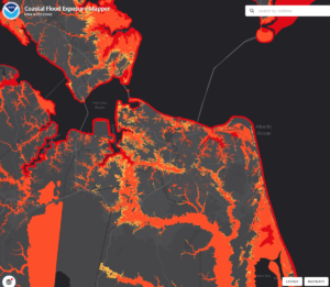
NOAA projects one foot of combined sea level rise and subsidence here in Hampton Roads by 2050. The adjacent map has not been updated to the new assessment. One more foot of water will turn most of the map orange and red – submerged and very submerged.

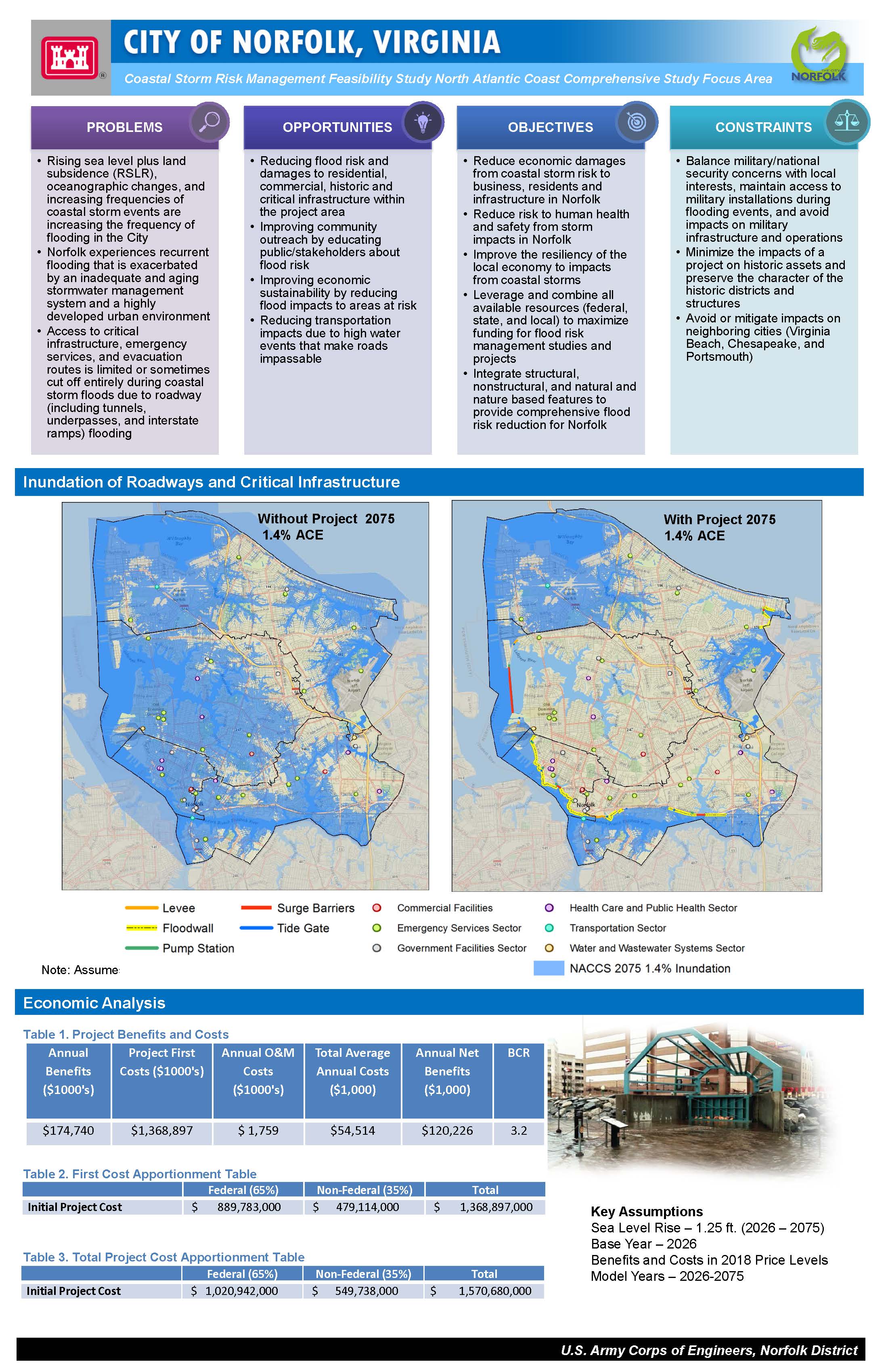
For larger scale perspective, see here.  For a thumbnail of a USACE storm risk management study of the City of Norfolk see here.

The Pilot editorial writer, approaching his conclusion, wanted to say something about green initiatives. So he did. The Regional Greenhouse Gas Initiative (RGGI) and such.

You can be for or against RGGI, but you cannot reasonably contend that it will stop flooding in Hampton Roads. The editorial is an example of green absolutism. That is one of the philosophies that has blocked state action on multi-jurisdictional flooding.

But it isn’t the only one.

The Moses complex. The thing about absolutists on the left and the right is that they must always ignore facts that don’t fit. In doing so about flooding, they fail to recognize that people organize under governments primarily for group safety.  Those governments must provide it.

One of the strangest things about flooding is that many people think their political positions will somehow make it go away. Or keep them safe and only drown the people who disagree with them.

Let’s look at the three sides that have actively opposed state action in coordination with the federal government on major flood control projects.

The green absolutists. One of the tragedies of the modern left is that its adherents think that they can hold back flooding with climate initiatives. A Moses complex.

I support clean water, clean air and more efficient ways to generate power. All of those, in my view, are good things where their value exceeds their costs — of all kinds. Pretty much how I feel about masking school children.

But the green left seems psychologically unprepared to accept engineering solutions to flood control. At least three reasons are worthy of consideration.

One school of thought is that such a position comes from a fear that the choice is either/or. That if engineered solutions are built and successful no one would want green solutions. That is a level of insecurity, like claustrophobia, that defies reason and facts. But it is there.

A second is that many greens will abide natural flood control solutions — shoreline grasses, wider beaches, clearing man-made obstacles to tidal flows, etc. — but not engineered solutions such as sea walls, tide gates, berms and levees. That has been the position of Virginia’s powerful greens. The fact that green solutions alone will not solve the problem does not bother them. Or maybe it does, just a little, because they will not mention that inconvenient fact.

The greens despise the U.S. Army Corps of Engineers (USACE) because they know that it is the organization that builds engineered solutions. They either do not know or do not care that it is also an agency that, by law, does everything feasible with green solutions before it considers man-made ones. Or that it is USACE that enforces clean water laws.

A final one is that the most deranged and vengeful of the greens — the kind that spike old growth trees to kill loggers- – think protecting the coasts and riverine communities from the ravages of flooding will somehow deny the earth the revenge it has earned for the man-made injuries it has suffered. This, in its gentlest version, is the move-away-from-the-water-or-drown crowd.

Those who defer to local governments. Conservatives want the level of government both capable and closest to the problem to provide the solution. That is my personal position.

It is also unequivocally true that tidal and riverine flooding cannot be dealt with solely at the local or regional government level in Virginia for at least three reasons.

  • It is too expensive for a local government acting alone;
  • Political will and resources are unequally distributed among adjacent jurisdictions. Local governments have tried and failed to band together in regional compacts to work with the federal government to get it done; and
  • Political boundaries are simply not a consideration to the water.

I have encountered a few Republican politicians who consider themselves protectors of local government authority when they vote against giving the state the authority to organize and lead multi-jurisdictional flood control.

They particularly object to the state serving as the agent — the non-federal sponsor — to deal with the federal government on those specific matters.

That position has not borne fruit. Local governments have proven incapable of doing it and single-point non-federal sponsorship is the only way the federal government, and its unmatched resources, will deal with multi-jurisdictional flooding.

I actually heard whispers among members of the General Assembly that if they just wait for a destructive hurricane, but hopefully not too destructive, the feds will pay 100% of the costs of both cleanup and future defensive measures.  =It isn’t true, but that does not mean they didn’t wish it so.

Those who have other plans for the money. = Did I mention that many state politicians do not want to pay the bill?

Louisiana, like Virginia, deferred to local governments — until Katrina. At that point, the state held an emergency session of the legislature to create an agency to serve as the non-federal sponsor.

USACE built the Hurricane and Storm Damage Risk Reduction System. It is an extraordinary 133-mile-long system of elevated levees, breakwalls, floodgates and pumping stations — and extensive green infrastructure. It was built by USACE. It cost $14.5 billion. The federal treasury lent Louisiana its share on 30-year terms.

As it turned out, Louisiana made more money in increased tax receipts directly traceable to the project than it ever owed for its share.

More importantly, in terms of maximum sustained winds at landfall, Hurricane Ida in 2021 was stronger than Katrina, and hit southwestern Louisiana directly. No lives were lost and property damage was minimal inside the protective system.

The study lobby. I have encountered this one up close and personal as well.

The state universities have found a gravy train in flooding studies and analysis that they fear will dry up when USACE gets involved.

The laser focus of the universities in this area is funding for studies. I told one of them once to prepare to print a million copies of his next study in case of major storm surge flooding. We could use them to fill sand bags. He appeared unhappy with me.

Another study lobbyist is the private engineering firm Dewberry. Virginia Beach spent $4 million with Dewberry for a sea-level rise and recurrent flooding study. I presume that company employs good engineers. I certainly don’t blame them for marketing their services. Good for them. If it helps Virginia Beach plan for recurring flooding from rain drainage issues and for the need to raise culverts, again good.

That firm has its eyes on doing the same thing for the state.

The problem is that if Virginia Beach or the state wants federal money for a project, USACE is required by federal law to do the same study. Again. From scratch.

Catch 22 is that if Virginia Beach wants to spend its own money on, say, a Lynnhaven River storm surge protection project built by a private firm, USACE has to do an assessment in order to grant the permit. Or not grant it.

Inertia and the lack of a lobby for state/federal action. Flooding is not something the General Assembly is used to dealing with. If you doubt that, look at the Bill Subject Index on Virginia’s Legislative Information Service. Try to find the word flood.

Why? There is no organized and funded lobby for multi-jurisdictional flood control.

The lobbies for other single issues should consider the effects of all of this on their own issues. Public education, healthcare, poverty, real estate, small business, whatever. Without protective measures, none survives a major flood unscathed.

The existing system. With the combined opposition of the greens — meaning pretty much all of the Democrats who take money from them — and some Republicans, the position of the General Assembly has been that local governments should organize to handle the problem.

The law defers to regional planning agencies, without giving those planning agencies executive authority. That has been tried and it failed. The local governments refused to defer to their own planning agencies.

What is left in Virginia — no policy at all — is deadly and destructive. Dressing up current policy with calls for more studies and reports is both a waste of precious time and the go-to approach.

Coastal and riverine flooding solutions are, in the United States, organized, funded and constructed as a combination of state and federal action.

It represents federalism at its most fundamental. The federal government, the states, and localities each have interests, rights and constituent safety responsibilities. However, the coasts and most of the larger rivers are not contained within any one state, much less any one municipality.

Writ large, the state is responsible for acting as the non-federal sponsor for multi jurisdictional projects. State responsibilities include organizing the local governments to participate as one, developing the support of the people for the project, providing certain contributions such as rights of way and transportation system adjustments. After the initial USACE assessments of federal interest, needs and costs, the non-federal sponsor must guarantee payment of 35% of the estimated costs or the plan will go no further.

The federal sponsor is the Congress. It approves the projects and writes the checks. The engineer and builder is USACE, the world’s largest civil engineering organization. It is uniquely experienced, staffed, equipped and capable in flood control.

State actions required. So it is left to the Governor and what should be bi-partisan majorities in the General Assembly to organize the state to participate in the existing federal-state program and, when called upon, to guarantee its share of the funding.

The Governor will have to make the case to the people of Virginia to get the General Assembly on board.

Congressional delegation actions required. It is the responsibility of Virginia’s congressional delegation to organize itself to get this done at the federal level.

Virginia has unique federal leverage if it will use it. The flooding threat to the military posture of the United States is centered in Hampton Roads. The Air Force and the Army can move elsewhere.

It is hard to move the Atlantic Fleet inland.

Virginia is unrepresented on the House and Senate committees that handle Water Resource Development Acts, the sources of project approval for flood control. That is a fundamental mistake, and one that needs to be remedied in the next session.

But it is well represented on the House Armed Services. And in the Senate Committee on Armed Services — Sen. Kaine is on the Seapower Subcommittee. Virginia is represented in Budget and Appropriations Committees in both houses.

Virginia’s congressional delegation must work as a team on this while the state is getting its act together to participate.

That same delegation must join the Governor in making the case to constituents. I hope they do it.


Share this article


ADVERTISEMENT

(comments below)


ADVERTISEMENT

(comments below)


Comments

40 responses to “The Real and Present Threat of Flooding in Virginia Requires Coordinated Action”

  1. Nancy Naive Avatar
    Nancy Naive

    Can you redraw the map and highlight the 7′ above mean high water contour for Steve’s benefit?

    1. Stephen Haner Avatar
      Stephen Haner

      That probably is the scary, imaginary 7 foot scenario. It is way higher than the 1 foot projected by NOAA the other day (which as I said was no higher and probably lower than earlier imaginings, but they peddled it as new.)

      The problem is real enough without exaggeration. But please do identify the source of that illustration and what it purports to show. I’m sure it does display the effect of a major hurricane, but not a 1-foot relative sea rise.

      1. Nancy Naive Avatar
        Nancy Naive

        What it shows is a greatly improved ICW.

        1. Stephen Haner Avatar
          Stephen Haner

          No idea what that is.

          1. Nancy Naive Avatar
            Nancy Naive

            Intercoastal Waterway. Commonly called “The Ditch”. 1000 miles of canals begun during the 1st US Administration. C’mon, didn’t you ever take US History?

            All the red lines, especially on the EC… https://i.pinimg.com/originals/e4/66/98/e46698b455911f26850b09dd1e5f0799.jpg

          2. Stephen Haner Avatar
            Stephen Haner

            Yeah, can drive a carrier there if that high!

          3. Nancy Naive Avatar
            Nancy Naive

            Oh please no. Bad enough sharing open waters with them and other drunken boaters. At least they finally started using Virginia Pilots after one of them hit a ship at anchor… on a clear sunny morning.

          4. Nancy Naive Avatar
            Nancy Naive

            Oh please no. Bad enough sharing open waters with them and other drunken boaters. At least they finally started using Virginia Pilots after one of them hit a ship at anchor… on a clear sunny morning.

          5. Nancy Naive Avatar
            Nancy Naive

            Okay, true story and without doubt, the meanest gesture of my life.

            Wednesday evening in the early 90s, and a submarine comes out of the Elizabeth and failed to turn right. Runs his boat up on Hampton bar 100 yards in front of me. Running full astern, throwing mud 50′ in the air, as as I sailed past his bow, I held up a coil of rope as the international gesture of offeing a tow.

            Locked eyes with a man in the lowest moment of his soon-to-end career.

          6. Wow! That was mean.

            It’s nothing that exciting, but my father and I once had a sub unexpectedly and suddenly surface about 50 yards from our 20′ sail boat. We were crossing the Thimble Shoal Channel* about a half-mile from the Chesapeake Bay Bridge Tunnel. It was quite a startling experience.

            * It was 40+ years ago and I’ve been away from the Bay a long time, but my memory is saying it was the Thimble Shoal Channel. In any event, it was the channel closest to the Va. Beach end of the bridge tunnel.

          7. Nancy Naive Avatar
            Nancy Naive

            Oh no. Yours is WAY more exciting because he had no idea you were there. Now imagine if you had been 50+/-2 yards closer.

            Uh yep. Thimble shoals channel. The other tunnel is the Baltimore channel.

          8. We did find it pretty exciting at the time.

            It had no numbers on its sail so I have no idea what, or what type of, sub it was.

          9. Nancy Naive Avatar
            Nancy Naive

            New construct on sea trials maybe?

      2. James C. Sherlock Avatar
        James C. Sherlock

        You will note that this is a FEMA Hurricane Map and labeled as such, Steve. It shows the 1% annual probability of flooding.

        You are conflating net sea level rise with storm surge.

        FEMA is not exaggerating. Storm surge was worse than that here in the Great Hurricane of 1933. Here is a picture of downtown Norfolk in that flood. https://www.baconsrebellion.com/app/uploads/2022/02/Norfolk-great-hurricane-1933.jpg

        One additional foot of relative sea level rise/subsidence in addition to the two feet that we have had since 1933 is three feet. Submersion of everything nine ft. above sea level. The highest point of land in South Hampton Roads other than Mt. Trashmore, a covered land fill, is at the airport. The airport runways are at 12 ft above meat high tide.

        For larger scale perspective, see https://www.baconsrebellion.com/app/uploads/2022/02/httpswww.nad_.usace_.army_.milPortals40docsNACCSAnnex_D_AppendicesNACCS_Appendix_D10_Virginia.pdf. For a thumbnail of a USACE storm risk management study of the City of Norfolk see https://media.defense.gov/2018/Jul/23/2001945759/-1/-1/0/180723-A-BJ794-002.JPG.

        1. Stephen Haner Avatar
          Stephen Haner

          Saw similar in downtown Roanoke in 1985 from the remnants of Juan.

          1. Probably not salt water, even if it was in downtown Big Lick.

  2. energyNOW_Fan Avatar
    energyNOW_Fan

    I know the Army Corps likes to dredge rivers to make them deeper for ship traffic, these days probably billion dollars from Uncle Sam. This happened in Philly/South Jersey, but we moved before I could stop it. Believe the Corps are in Massachusetts now based on the recent news items about mysterious yellow tubing on the Cape Cod beaches, from the Boston Harbor Dredging project.

    In NJ the elected officials said the oil industry wanted the river to be deeper for supertankers. But eventually the oil industry had to say (very nicely) , actually, that was elected officials vision about the super tanker capability, and there was really no industry plans or need for that.

    Maybe we need less dredging and more focus on sea level rise adaption. Like utilities, the elected officials love this Army Corps activity due to money coming in and also some officials own the property the Corps need for the projects. Win/win.

    Mysterious yellow plastic strands:
    https://money.yahoo.com/mysterious-yellow-plastic-strands-cape-095810217.html

    1. Nancy Naive Avatar
      Nancy Naive

      No sweat. If there is a rock on the Chesapeake’s bottom, it was put there. Nothing but oyster shells 10′ deep in a black mud that sucks in anchors like M&Ms.

  3. walter smith Avatar
    walter smith

    I start with are we really sure the NOAA projections have any validity?
    Is it captured by “Big Climate?”
    I think true scientific neutrality and skepticism have been ruined by politics and money.
    Here is some skepticism about the NOAA…https://www.manhattancontrarian.com/blog/2022-2-20-the-greatest-scientific-fraud-of-all-time-part-xxx

    1. James C. Sherlock Avatar
      James C. Sherlock

      The subsidence part of the relative sea level rise is measured by NASA. Here is the subsidence map. https://www.baconsrebellion.com/app/uploads/2022/02/NASA-Subsidence-Map.png

      1. walter smith Avatar
        walter smith

        I get that. I doubt that we know everything about why it is happening and suspect it will for unknown reasons also go down. But I don’t know. And admit it!

    2. Stephen Haner Avatar
      Stephen Haner

      I am sure they are overblown. But the measured relative sea level rise is half a foot over 30 years. That will still exacerbate future flooding and drainage problems.

      1. walter smith Avatar
        walter smith

        And is that something cyclical we don’t know about?
        I think of the Maunder Minimum in world temperature and other events that happen over time that Man has nothing to do with. Are things occurring currently with the rise? Are pockets where wells used to be gradually getting refilled, etc?
        There is no way we know everything and the assumptions cannot possibly comprehend anything, AND they are biased politically and economically…but other than that!
        You are a voice of sanity in this area, but the critics discredit you because you are paid or a lobbyist (I don’t know – but it doesn’t mean you are wrong), while of course, your critics don’t care about power or money – virginally pure…

        1. Stephen Haner Avatar
          Stephen Haner

          The sea level rise and fall is largely tied to the glacial and interglacial cycles. As in, they’ve been rising overall since the last ice age.

          1. James C. Sherlock Avatar
            James C. Sherlock

            That, and a rowboat, will get you out of Virginia Beach after a category 3 hurricane passing near Norfolk.

  4. Nancy Naive Avatar
    Nancy Naive

    While on the subject of money, I find it interesting that when the Markets are closed, CNBC runs episodes of “American Greed”, a show about investor bilking.

  5. Stephen Haner Avatar
    Stephen Haner

    Things Sherlock ignores in this rant. Virginia Beach is moving forward with control program funded by a local tax supplement, approved in a referendum. The state did create a revenue stream with RGGI, not enough really and it should be funded another way. I’d hate RGGI less if 100% went to this purpose. And Gov. Youngkin put in a bill to create a statewide coastal protection authority, something I thought Capt. Sherlock liked. He put it on his Day One list and the Democrats killed the Senate version, just because. But the House version still lives I think.

    The category on Legislative Information Services is “Waters of the State.” Check it out, Sherlock:

    https://lis.virginia.gov/cgi-bin/legp604.exe?000+sbj+062

    Search the word “coastal” and you get this list from just this year:

    http://leg1.state.va.us/221/lst/LS218454.HTM

    Your complaint the issue is ignored is without basis.

    1. James C. Sherlock Avatar
      James C. Sherlock

      Gov. Younkin’s bill is HB 847 Virginia Resiliency Authority; established, definitions, report. is a first step. I was on the transition team that requested this step. It has crossed over to the Senate, where it faces daunting odds in Appropriations.

      The Senate version of the same bill, SB569, passed in Agriculture, Conservation and Natural Resources with substitute (11-Y 4-N).

      The FIS https://lis.virginia.gov/cgi-bin/legp604.exe?221+oth+SB569F122+PDF was not daunting, but SB569 was passed by until next year in Senate Appropriations. Every Democrat on Appropriations voted against it. Every Republican voted for it.

      The Democrats and their green funding machine have not wanted a state authority to serve as non-federal sponsor to deal with USACE in the process of building storm surge defenses, which is my point exactly. If such an authority is not created, the federal money will remain beyond reach. Which means the defenses will remain beyond reach.

      I hope HB 847 survives in the Senate, but it looks unlikely.

  6. Stephen Haner Avatar
    Stephen Haner

    https://media.defense.gov/2018/Jul/23/2001945759/-1/-1/0/180723-A-BJ794-002.JPG

    I’m not sure this link was part of the post when I first saw it. Good addition. Hey, give this a fudge factor and call it $200M. Seems like a very viable plan to protect against a major hurricane, which is inevitable. Between state, local and federal funding and bonded over a couple of decades, it should be done.

    1. James C. Sherlock Avatar
      James C. Sherlock

      The issue is that it would be far more cost effective to protect all of the military bases, port facilities and bedroom communities in South Hampton Roads than for Virginia Beach, Norfolk, Chesapeake, Suffolk and Portsmouth to each go it alone. USACE only studies and reports on projects that are approved by Congress. The Norfolk and Northern Virginia portions of that (North) East Coast study were authorized and funded after Sandy. Norfolk was the southernmost coastal city studied.

      To explain the cost-effective issue, Norfolk, assessed alone under the terms of the authorization, is defended from flooding by the resulting design not only from the Chesapeake Bay and Hampton Roads but also from Virginia Beach to the east by protecting the Norfolk side of the Elizabeth River.

      If the study were to look at South Hampton Roads as a single project, a significant portion of the defenses of Norfolk alone would be redundant.

  7. tmtfairfax Avatar

    Only an idiot would not examine engineering solutions to flooding. Indeed, the MWCOG’s TPB and member jurisdictions are looking at various scenarios, higher water levels, more storm water, greater heat, etc., and their impacts on transportation and other public infrastructure. This makes sense.

    Interestingly, Fairfax County is also looking at public utility infrastructure with private sector entities, as well as government ones. Looking at attendance records, I noticed that Dominion Energy has missed some meetings. Is anyone surprised?

    I do know some people who are quite intelligent but not very interested in resiliency. They prefer a world where everyone lives in a cramped apartment in central cities, have foregone motor vehicles (maybe a shared EV is OK) for transit. I guess this is the hairshirt and misery approach.

    1. how_it_works Avatar
      how_it_works

      Speaking of Dominion Energy, I saw this fine example of Virginia engineering:

      https://uploads.disquscdn.com/images/a3f097f25423420573707f79a1045d7e6e6bbfc94fc001a2a2376fdc5887f6c6.png

      The corner of that power transmission tower appears to be 14 feet from the road.

      Do people really put critical power infrastructure this close to a 2-lane road with no shoulder?

      They do in Virginia.

  8. Eric the half a troll Avatar
    Eric the half a troll

    Ummm.. for the record, I am green and reside on the left. I am not against engineered solutions (although I do believe natural solutions tend to be better and have far fewer unintended consequences and I am unhappy that we have to turn to engineered solutions at a terrific cost). I support and respect the USACE. They do great works to be sure and we are all better for it. And I certainly do not wish for anyone to drown from any flooding (although I don’t really care if some millionaire loses his vacation house he built on a spit of sand… another story…).

    Are we faced with the possibility that should we install robust flood control measures (if the USACE is involved they will likely be very robust) suddenly development pressures resurge behind the control measures because “hey, it’s safe there” and a great cycle begins again…? I honestly don’t know but I wouldn’t be surprised…

    1. James C. Sherlock Avatar
      James C. Sherlock

      Do you think that possibility should stop protection measures?

      1. Eric the half a troll Avatar
        Eric the half a troll

        No. of course not. I do think after we finally do fix this situation though (I believe we will fix it eventually – hopefully before lives are actually lost) that land use regulations are in place to stop that possibility. That action likely WILL have to come from local authorities (and it should). Not sure they will have the political will or desire to enact such a change though.

    2. “Suddenly development pressures resurge behind the control measures” — this is a quandary. Local government has the financial incentive to grow its tax base and encourage development behind the levies. The federal authorities have finally pushed FEMA to charge flood insurance rates approaching the real risk of loss, but those rates come down when the risk of loss comes down. So how discourage behind-the-walls development? I think much depends on why the walls are built, how they are cost-justified, in the first place: to protect existing structures and uses, or to expand the develop-able flood plains? And my understanding — without research — is that the feds (e.g., USACE) will not accept development potential as an offsetting benefit in cost-benefit analysis. There are a lot of games to be played in this area, however.

  9. Another study lobbyist is the private engineering firm Dewberry. Virginia Beach spent $4 million with Dewberry for a sea level rise and recurrent flooding study. I presume that company employs good engineers.

    They do.

  10. Another study lobbyist is the private engineering firm Dewberry. Virginia Beach spent $4 million with Dewberry for a sea level rise and recurrent flooding study. I presume that company employs good engineers.

    They do.

  11. Paul Rocheleau Avatar
    Paul Rocheleau

    I continue to be amazed at the lack of knowledge/understanding regarding subsistence in the lower bay and Norfolk area. Please go to wikipedia and Nat’l Geologic Surveys and read about the Chesapeake Bay Impact Crater. The area continues to “slough”, or sink into the crater formed approx 35 million years ago. Explains why “relative” sea level change is worst in Norfolk than elsewhere. Relatively recent discovery and science that does not fit the established narrative.

Leave a Reply