New Offshore Wind Power Project Proposed to Come Ashore in a Virginia Beach Flood Zone

by James C. Sherlock

There is a dominant engineering problem in bringing offshore wind-generated electricity ashore in Virginia Beach. Flooding and water tables very close to the surface are the twin reasons there are few basements in Virginia Beach. And those that have them regret it.

The 2020 Virginia Beach FEMA Flood Hazard Map is 56MB. It is too big to display here. So don’t try downloading it on a phone. But take a look. It is important to the discussion.

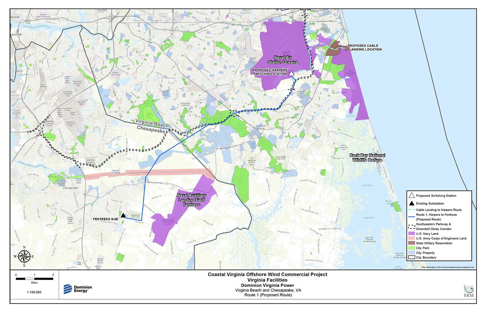
Camp Pendleton and Sandbridge are Virginia Beach shore landing spots proposed for offshore wind electricity generated by two different fields. Both will have similar infrastructure pictured below.

courtesy https://coastalvawind.com/about-offshore-wind/delivering-wind-power.aspx

Below is the SCC-approved transmission line route from Camp Pendleton for the Coastal Virginia Offshore Wind (CVOW) project. The map does not show flood hazard zones.

I am not sure any public version of it ever did.

CVOW Project onshore routing.  courtesy https://coastalvawind.com/about-offshore-wind/delivering-wind-power.aspx

I have not yet seen the onshore routing proposed for the as-yet-not-approved Kitty Hawk Offshore Wind (KHOW) project from Sandbridge to its three proposed grid interconnection points inland.

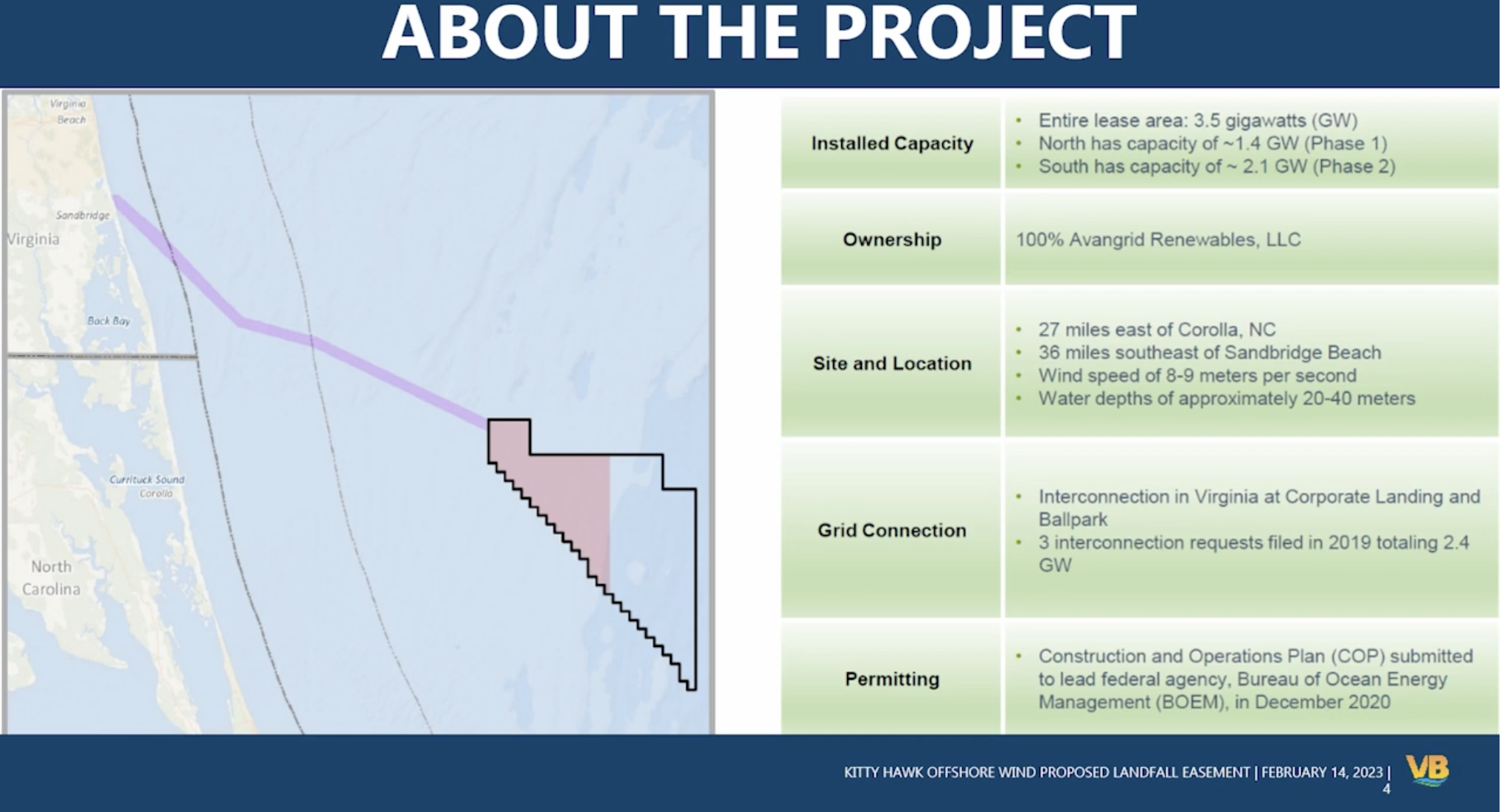
The KHOW Project landing site is proposed at Sandbridge because the contractor’s assessment is that the grid infrastructure in North Carolina won’t be able to handle it.

We hope Virginia’s will.

Coastal storm surge raises potential problems at both landing sites, but especially Sandbridge, which will be overwashed in the FEMA projections.

Between Sandbridge, a barrier island, and the mainland is a swamp. The (up to six) cables are to be underground the entire way to the switching station or stations inland.

I have no doubt that the engineering by Avangrid Inc., the contractor, took this into account. But Virginia Beach Public Works, with a huge dog in the fight, has reportedly only recently seen the proposal.

The obvious questions include:

  • what will the final product — transmission lines/towers, switching stations, onshore substations — look like in Virginia Beach beyond the landing sites;
  • the proposed manhole access to the cables at the city’s parking lot at the beach raises storm surge over-wash issues;
  • the corrosive effects of the very high and brackish water tables along the routes at which the onshore export cables are underground;
  • any flooding mitigation required;
  • the impact on the Virginia electric grid;
  • Where and how any utility-scale storage batteries will be located when the technology is available; and
  • any accommodations that may necessary with existing city utility infrastructure.

The Virginia Beach City Council postponed a vote on the Sandbridge project.

The Council representative from Sandbridge, Barbara Henley, did not appear amused by the presentation by the City Manager, especially because Virginia Beach Public Works reportedly had not had time to study it.

Our city’s Public Works has impressed me with their engineering work in the past. It will be interesting to hear their take on the project.

Perhaps the Council will ask that the KHOW project proposal be displayed on the FEMA flood map the next time it is discussed.

If so, I expect those above are some of the questions they will be asking.

KHOW, if approved, may well work as pictured or be rerouted. But there are a lot more questions to be asked and assessments yet to be done.

Using the flood maps.


Share this article


ADVERTISEMENT

(comments below)


ADVERTISEMENT

(comments below)


Comments

66 responses to “New Offshore Wind Power Project Proposed to Come Ashore in a Virginia Beach Flood Zone”

  1. WayneS Avatar

    Coastal plain areas have flood and storm surge hazards. The same issues will be in play wherever cables are brought ashore.

    1. James C. Sherlock Avatar
      James C. Sherlock

      Not really. Most of America’s coasts are not coastal plains. We in Virginia Beach are proudly hosting the first coastal plain project here I believe.

      1. Lefty665 Avatar
        Lefty665

        The east coast mostly is. Like from Florida north to what until you get to New England?

      2. WayneS Avatar

        “Not really” what?

        My first statement is 100% correct.

        My second statement is correct within the bounds reason. We are not discussing most of America, we are concentrating on the mid-Atlantic region of the east coast of America, the coastlines of which are comprised almost entirely of coastal plain.

        Of course, I suppose you could be suggesting we bring the cables ashore on the coast of Maine, or Oregon – but that would be outside the bounds of reason- so, again, my statement is correct.

        I think Ocean Wind 1 off the coast of New Jersey is ahead of both Virginia and North Carolina in planning and design of their offshore wind farm.

  2. Dick Hall-Sizemore Avatar
    Dick Hall-Sizemore

    That “swamp” you referred to as being between Sandbridge and the mainland is part of the Back Bay National Wildlife Refuge. I wonder if the developer of the KHOW project have applied for permits to lay their cables through there.

    1. Eric the half a troll Avatar
      Eric the half a troll

      Not sure but I believe it is a freshwater bay. Interesting but not important most likely.

      1. Dick Hall-Sizemore Avatar
        Dick Hall-Sizemore

        Back Bay itself is fresh water. The bay is not connected to the ocean. However, the wildlife refuge has a long beach front. With the extensive dunes and the deserted beach, it is pretty neat.

      2. WayneS Avatar

        Yes, it is considered fresh water.

        Back Bay can become ‘brackish’ for a while after big storms, if flooding or storm surge causes it to “join” the ocean. Normally, however, it’s closest point of contact with the Atlantic Ocean is about 45 miles south, via Knotts Island Bay, Currituck Sound and Albemarle Sound.

    2. James C. Sherlock Avatar
      James C. Sherlock

      I think they are trying to get early sign-off from Virginia Beach. Lots more hoops to jump through. USACE permits may prove an obstacle, but that organization will be under a lot of pressure to approve.

    3. WayneS Avatar

      I think the swamps he is referring to are North Bay and the northern end of Shipps Bay.

      Back Bay, and the wildlife refuge, are south of the proposed route of the cables.

      CORRECTION: The Back Bay Wildlife Refuge is not contiguous, and while 75-80% of it is located south of Sandpiper Road, there are little bits and pieces of property all over the area that are part of the refuge.

      However, my main point is still valid – the proposed landing area and pipe route certainly appear to avoid the properties that are in the refuge.

      There is a map here: chrome-extension://efaidnbmnnnibpcajpcglclefindmkaj/https://pubs.usgs.gov/ds/754/NortheastRegion%28R5%29/Back%20Bay%20NWR%20-%20NWR%20visitor%20survey%202012.pdf

      1. Dick Hall-Sizemore Avatar
        Dick Hall-Sizemore

        Steve, in an earlier post, had indicated that the plan was to run the cables underground along Sandbridge Road, which is problematic in and of itself. As the map below shows, Sandbridge Road runs smack dab through the middle of the northern portion of Back Bay property. https://www.fws.gov/refuge/back-bay

        1. WayneS Avatar

          If you look very closely at the map you will see that Sandbridge Road is not identified as part of the refuge. Most of the parcels at Sandbridge on the north and south side of the road are, indeed, part of the refuge, but not the road itself. It might be one of the reasons they intend to run it along the road instead of going “cross-country”.

        2. WayneS Avatar

          If you look very closely at the map you will see that Sandbridge Road is not identified as part of the refuge. Most of the parcels near Sandbridge on the north and south side of Sandbridge Road are, indeed, part of the refuge, but not the road itself. It might be one of the reasons they intend to run the cables along the road instead of going “cross-country”.

    4. James C. Sherlock Avatar
      James C. Sherlock

      I think they are trying to get early sign-off from Virginia Beach. Lots more hoops to jump through. USACE permits may prove an obstacle, but that organization will be under a lot of pressure to approve.

  3. Eric the half a troll Avatar
    Eric the half a troll

    “…the corrosive effects of the very high and brackish water tables along the routes at which the onshore export cables are underground;”

    Aren’t they coming out of the ocean…?🤷‍♂️

    1. James C. Sherlock Avatar
      James C. Sherlock

      If I understand your question correctly, they lay on the bottom of the ocean and will be brought out just below the beach, with manhole access under the city’s parking lot at the north end of the beach.

      Very different environments.

      Not sure if the same cable protection wrappings, including the armoring, are appropriate for both or if they have to transition. But troubleshooting the underground cables will be different, and likely harder, than for those underwater.

      1. WayneS Avatar

        But troubleshooting the underground cables will be different, and likely harder, than for those underwater.

        It think you have that backwards. It should be easier to troubleshoot an underground cable with manhole access points than one at the floor of the ocean which requires diving apparatus to get near it.

        1. how_it_works Avatar
          how_it_works

          What if the manholes are flooded along with the ducts/conduits between them?

          Although they say there’s only two kinds of underground conduit…

          ..ones that have water in them and ones that will get water in them.

  4. William Chambliss Avatar
    William Chambliss

    Many, if not all, of the obvious questions will need to be addressed by the prospective developer in an application to the SCC before it will be permitted to build anything in Virginia.

    1. James C. Sherlock Avatar
      James C. Sherlock

      They will, but our City Council is ready to give approval in advance of all that. They were ready last month if not objected to by Ms. Henley.

  5. Nancy Naive Avatar
    Nancy Naive

    Virginia Beach IS a flood zone.

    1. James C. Sherlock Avatar
      James C. Sherlock

      Precisely.

      So it is relevant to us who study our personal evacuation routes to ask what happens to the new high voltage electrical system including batteries when everybody leaves under mandatory evacuation orders.

    2. James C. Sherlock Avatar
      James C. Sherlock

      Precisely.

      So it is relevant to us who study our personal evacuation routes to ask what happens to the new high voltage electrical system including batteries when everybody leaves under mandatory evacuation orders.

    3. James C. Sherlock Avatar
      James C. Sherlock

      Precisely.

      So it is relevant to us who study our personal evacuation routes to ask what happens to the new high voltage electrical system including batteries when everybody leaves under mandatory evacuation orders.

      1. Nancy Naive Avatar
        Nancy Naive

        Yeah, but so is NC from Duck to Roanoke Rapids.

        New Bern is now flooding regularly. If high ground is your criterion, then Cove Point is where it should come ashore, right next to the LNG terminal.

        Wait?! You think you have an evacuation route? Now that is funny.

        An evacuation route for VB is like an ABM system in Poland to defend Europe from Iranian LR missiles. The ABM has to launch first.

        1. James C. Sherlock Avatar
          James C. Sherlock

          Best I remember, there are no pop-up hurricanes

          1. Nancy Naive Avatar
            Nancy Naive

            Just, uh, keep a battery powered chainsaw and a gallon of white paint in the attic. Your best evacuation route is via USCG helicopter.

          2. how_it_works Avatar
            how_it_works

            The heat in the attic will kill any battery in a chainsaw in short order.

          3. Nancy Naive Avatar
            Nancy Naive

            The heat in my trunk still takes way more than a year to discharge my emergency start battery. I suspect if you charge the battery every spring, then it’ll last to November. If you’re a purest, keep the battery in the fridge.

          4. how_it_works Avatar
            how_it_works

            Different battery chemistry, most likely. Jump packs mostly still use sealed lead acid batteries.

            Electric chainsaw will most likely use lithium-ion.

            Lithium-ion batteries don’t like temperature extremes that sealed lead acid batteries have no problem with.

          5. Nancy Naive Avatar
            Nancy Naive

            Nope, it’s a lithium. I have 3, including the one I bought for the daughter unit’s car.

            Could be LiFePro, I suppose. But, it’s not lead-acid. Weight and size rule that out — imagine 5 iPhones stacked. And, they’re 8 AMP, absolutely foolproof (have reversed polarity lockout and shut off automatically when the alternator kicks in), and have a USB outport too.

            Look ‘em up. Buy one for the wife.

          6. WayneS Avatar

            8 amps? Even at 8 amps each, is 40 amps sufficient to activate the starter and fuel system and ignition system in a car?

            My current car battery provides something like 550 CCA.

          7. how_it_works Avatar
            how_it_works

            You need at least 100 amps to turn the starter over on the smallest engine in the most ideal conditions.

          8. Nancy Naive Avatar
            Nancy Naive

            8 AMP is enough to boost your 50% discharged car battery to a level that gives 30 seconds of cranking. Given nothing else wrong, it shouldn’t take that long.

            New cars suck. In the old days, you knew that your battery was getting weak. You get a slow start or two warning. Not anymore. When that sucker drops below 12, or 11.8 V, the ignition just goes click.

            When the daughter went off to college, I bought her a roadside emergency kit, and the emergency battery.

            She never had a problem, but she started other kid’s cars, and even used the tow rope to pull a kid’s car out of a ditch.

            She still uses that battery on camping trips.

          9. WayneS Avatar

            Okay. That makes sense.

          10. how_it_works Avatar
            how_it_works

            I just bought some solar chargers for the vehicles I don’t drive often. Should avoid the need to jump them or put a battery charger on them.

          11. Nancy Naive Avatar
            Nancy Naive

            Those are great. It doesn’t have a charge controller. Basically, they just throw 13.8V at 1 AMP at the battery all day. It would take a week of bright sun to charge the battery, but it will sustain it forever.

          12. WayneS Avatar

            Water-based paint. A can of oil based paint might spontaneously combust in your attic…

          13. Nancy Naive Avatar
            Nancy Naive

            Uh, take the risk. You don’t want the SOS washing away in the rain.

          14. how_it_works Avatar
            how_it_works

            I’m pretty sure that the flash point of the solvents used in oil paint are much higher than the temperatures expected in an attic.

          15. WayneS Avatar

            Some oil based paints, when still in liquid form in the can, have a flashpoint between 100 and 200 degrees Fahrenheit .

          16. how_it_works Avatar
            how_it_works

            My mistake–I meant the autoignition temperature.

            Chances are if you can smell it that the ambient temp is above the flashpoint.

        2. WayneS Avatar

          I lived with my family in Virginia Beach from 1965 until 1985. My parents lived there an additional 7 years after I moved away. My family never even considered evacuating our home due to an approaching storm.

    4. James C. Sherlock Avatar
      James C. Sherlock

      Precisely.

      So it is relevant to us who study our personal evacuation routes to ask what happens to the new high voltage electrical system including batteries when everybody leaves under mandatory evacuation orders.

  6. David Wojick Avatar
    David Wojick

    The About page wind speed is interesting. Must be the predicted average because wind varies from zero to near 200 mph. They give it in meters per second which almost no one understandes. A meter per second is just over 2.2 miles per hour, making their average 17-20 miles per hour (mph). Wind turbines start generating around 10 mph but require 33 mph or so for full power. So their average is less than half power. Ridiculous especially since there is no reason to build this junk in the first place.

  7. Stephen Haner Avatar
    Stephen Haner

    The Kitty Hawk plan is to use existing right of way, to lay these power cables into or alongside buried conduits that already exist, carrying other major utility lines. Mr. Sherlock’s idea that he has found some new angle on this, something all the others didn’t see or didn’t think about, seems a stretch. I suspect they have to plan for periods of inundation. The substations they are heading for are more vulnerable to flooding, but also on higher ground I assume or otherwise protected. Not a new idea, a substation in ocean front cities. Planning for hurricanes is kind of front of mind for those places.

    Now, to get to those logical access routes they bring the cables ashore across the main Sandbridge public beach and that central parking lot and tear it up for a long period. Had they set out looking for a plan to create local anger, they couldn’t have found a more sensitive place.

    1. James C. Sherlock Avatar
      James C. Sherlock

      Thanks, but take a breath. I wrote that the company had certainly considered the implications of which they are aware, Steve. Check again.

      The “carrying other major utility lines” part is one of the many issues that the city engineers need to look at. Before the Council votes. If you watched the City Manager try to brief the project, it was embarrassing. See the YouTube link.

      And the citizens of Virginia Beach certainly deserve more information than we have been getting.

      It is OK if we would like to know the effect of flooding on the entire project.

      So, as I said, take a breath.

      1. Stephen Haner Avatar
        Stephen Haner

        You live there. I don’t. You want to get your fellow residents fired up, go for it. As I already reported, another major public hearing is coming. When (not if) the Cat 5 hits square on, this won’t be the big concern.

        1. Nancy Naive Avatar
          Nancy Naive

          Category 5? Off the Va Capes? Not without climate change.

          If the past is any indication of the future, then in a pig’s eye.

          https://www.nbc12.com/2021/05/27/central-virginias-top-worst-hurricanes-3/

          BTW, the best evacuation routes for Hampton Roads is a bucket of white paint and a 10” Ryobi chainsaw. You want battery powered ‘cause you won’t want to run a gasoline chainsaw in the attic.

          1. James Wyatt Whitehead Avatar
            James Wyatt Whitehead

            1769 Hurricane blew the top off of Stratford Hall. That was felt from Williamsburg to Boston.
            https://en.wikipedia.org/wiki/Great_Chesapeake_Bay_Hurricane_of_1769

          2. Nancy Naive Avatar
            Nancy Naive

            So, 250+ years ago. Okay, I think the windmills might have a problem.

          3. Stephen Haner Avatar
            Stephen Haner

            Cat 3 will be bad enough.

          4. Nancy Naive Avatar
            Nancy Naive

            Hyperbole is my job. You were stepping on it.

      2. Stephen Haner Avatar
        Stephen Haner

        You live there. I don’t. You want to get your fellow residents fired up, go for it. As I already reported, another major public hearing is coming. When (not if) the Cat 5 hits square on, this won’t be the big concern.

  8. Nancy Naive Avatar
    Nancy Naive

    Part of the job of power generation and distribution is proper location of equipment, like, oh say, North Anna, running pipelines through and building power plants in protected watersheds. Why, heck, even putting high power lines over rivers and golf courses.

    1. how_it_works Avatar
      how_it_works

      Putting overhead distribution lines in heavily treed areas, and never trimming the trees so they cause a power outage is a Dominion specialty.

      There’s even a place where Dominion put a transmission tower less than 10 feet from the edge of a roadway.

      A little planning goes a long way….

      1. Nancy Naive Avatar
        Nancy Naive

        God, I hope it was on a “breakaway” pole. Hitting it with a car could kill someone.

        1. how_it_works Avatar
          how_it_works

          No. It’s not. It’s one of those huge steel lattice transmission towers with probably 230kV lines. I took one look at that and thought.. “Planning like that is why your ancestors lost that war…”

      2. WayneS Avatar

        Are you certain the road was there before the tower?

        1. how_it_works Avatar
          how_it_works

          It’s a two-lane country road with no shoulders, and poor horizontal and vertical alignment. It also, if I recall correctly, has a route number in the 600s.

          There’s no doubt that the road was there before the tower. It was probably there over 100 years ago, if not prior to the war. It has every characteristic one would expect of a typical Virginia rural road that got paved during the Byrd administration and never had any improvements done to it since (expect maybe the painting of a center line).

          Even if the tower was there before the road, then that just makes it poor planning on someone else’s part.

        2. how_it_works Avatar
          how_it_works

          It’s a two-lane country road with no shoulders, and poor horizontal and vertical alignment. It also, if I recall correctly, has a route number in the 600s.

          There’s no doubt that the road was there before the tower. It was probably there over 100 years ago, if not prior to the war. It has every characteristic one would expect of a typical Virginia rural road that got paved during the Byrd administration and never had any improvements done to it since (expect maybe the painting of a center line).

          Even if the tower was there before the road, then that just makes it poor planning on someone else’s part.

          1. WayneS Avatar

            Yep. It was probably put in place after the road.

            You know, some of us very much enjoy driving/riding on 600 numbered roads with poor horizontal and vertical alignments. Poor vertical alignment less so than horizontal, but still…

            😉

          2. how_it_works Avatar
            how_it_works

            My issue with them is mainly the interrelated problems of poor pavement quality (seems like VDOT can’t get the pavement to last more than a few years before it needs to be redone) and poor drainage.

            Hitting a puddle of standing water at 45MPH is exciting.

          3. WayneS Avatar

            Hitting a patch of gravel in a curve on a motorcycle at 70 mph is also kind of exciting.

          4. how_it_works Avatar
            how_it_works

            If you neglect asphalt enough, it becomes gravel.

  9. energyNOW_Fan Avatar
    energyNOW_Fan

    Is there is a bit of hypocrisy in green energy? We are building offshore wind due to, according to liberals, near certain Armageddon and sea level rise in Virginia expected 5-ft by Year 2100 by some. Does anybody really believe this? Actually it is probably not impossible, but I’ll believe it when I see it.

    The “good news” is if 5-ft sea level rise does happen, perhaps lots of public tax money will be spent on sand replenishment to save the many East Coast offshore wind farms, and Sandbridge will be thusly preserved.

    Sort of continuing the tradition of heavily insuring the rebuild of seafront property after it gets wiped out.

Leave a Reply