Chesterfield’s Slow-Motion Suburban Suicide

by James A. Bacon

The traffic engineers, it appears, have won. Chesterfield County is doubling down on suburban sprawl with plans to build a series of “superstreets” at a cost of tens of millions of dollars over the next decade. While the massive infrastructure investment likely will reduce traffic accidents and improve traffic flow on the streets themselves, they will literally cement into place the county’s dysfunctional land use patterns.

This article in the Chesterfield Observer lays out the rationale behind the superstreet concept. “It provides for a high-capacity roadway, and also safety because you don’t have these intersections where [cars] cross paths in front of each other. It’s a way to eke out additional capacity without widening,” says Jesse Smith, the county’s transportation director. According to the Observer, work on the first project, on Iron Bridge Road (Route 10), will cost $64 million and is scheduled for completion in the spring of 2022.

Greater Greater Washington critiques Chesterfield’s superstreet in a recent blog postGGW questions whether the added transportation capacity is needed, argues that the superstreet design rules walking and biking in the corridor, and contends that the money could be spent more effectively elsewhere, such as mass transit. The critique is worth a read. I agree with much of it, but differ in important respects.

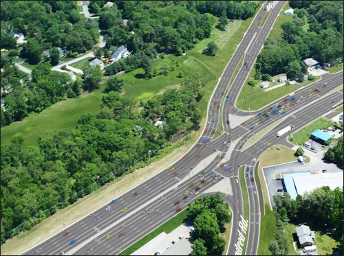
The superstreet traffic simulation, prepared by the McCormick Taylor engineering firm (see the Youtube clip above), has a certain austere beauty to it. It does appear to move cars with awesome efficiency. If the sole focus of planning is the flow of automobiles within the confines of the project itself, then superstreets are a marvelous thing. But if viewed in a larger transportation/land use context, the concept has severe drawbacks.

No walking/biking. As the GGW account notes, the superstreet designs do not accommodate pedestrians or bike riders. It’s my recollection from having driven on Iron Bridge Road a few times that the road does not accommodate  pedestrians or bikers now, so a superstreet wouldn’t make matters any worse. Let’s imagine for a moment that Chesterfield decided to add sidewalks and/or bike paths to the project. Given the scattered, low-density pattern of development along Iron Bridge, hardly anyone would use them. Here’s what GGW overlooks: To make walking/biking a viable transportation option, Chesterfield needs to change its land use to support walking and biking.

Forget mass transit. Same thing with mass transit. GGW points to the City of Richmond’s Pulse bus-rapid-transit system running down Broad Street as an example of an alternative investment that would make more sense. Bus Rapid Transit has a chance to work for Richmond (the verdict is not yet in) because development is denser, sidewalks already exist, and the city put zoning into place that allows for property owners and developers to build mixed-use projects, re-develop at higher densities, and evolve toward Walkable Urbanism. None of those conditions exist on Iron Bridge Road. At present, mass transit is a fantasy.

Killing any hope of walkable urbanism. But I agree with GGW that spending $65 million to build a 13-lane superstreet is a terrible idea. By creating an impenetrable barrier for anything but motorized vehicles, superstreets carve up the landscape and make the county more automobile-dependent than ever. Superstreets also destroy any hope that the transportation corridor, including the parcels along it, might one day evolve into a walkable urban area.

Walkable urbanism would offer at least four critical advantages to a county like Chesterfield. First, it would generate more tax revenue per acre without adding significantly to the cost of infrastructure maintenance. Second, by placing a mix of retail, office, and residential uses within close proximity, it would allow people to substitute walking trips for automobile trips, thus taking cars off the road. Third, it would improve the economics of mass transit, should that option ever be pursued. Fourth, there is a shortage of Walkable Urbanism in the metropolitan real estate marketplace. If Chesterfield wants to compete for tax-paying businesses and affluent residents, it will need to build its inventory of walkable urban places.

Here’s the rub: You can’t create walkable urbanism overnight. Chesterfield has a problem similar to that of Fairfax County. The “bones” of its transportation corridors — roads, intersections, sidewalks, drainage, curb cuts, and the like — are deeply set. They will be expensive to rebuild. Unlike Fairfax County, Chesterfield does not have a dynamically growing economy that can generate the resources needed to finance that rebuilding.

So, it won’t be easy. However, it can be done. Step one: Stop subsidizing superstreets and other sprawl-inducing transportation projects. Step two: Re-envision what the county transportation corridors — roads, infrastructure, parcels — can look like as walkable urbanism, and create a pathway for getting from A (what there is now) to B (what you want). Step three: Amend the zoning code and comprehensive plans as needed. And step four: Reallocate money from sprawl subsidies to projects that “reset the bones.” Don’t spread the investments thin so they make no notable difference. Identify the locations with the greatest potential and invest heavily there to create critical mass.

The traffic engineering mindset is a dead end. Chesterfield planners need to think more holistically.


Share this article


ADVERTISEMENT

(comments below)


ADVERTISEMENT

(comments below)


Comments

14 responses to “Chesterfield’s Slow-Motion Suburban Suicide”

  1. Reed Fawell 3rd Avatar
    Reed Fawell 3rd

    WOW! How cool is that!!! McCormack Taylor building 1950s t0 year 2015 Northern Virginia brand new and all over again, just like Til’ and his gang’s rampage through outer beltways wild west speculation land rush DO DA DAYS.

    It’s there for all to see: Virginia’s developer fed highway planning at its absolute worse, all to the tune of 1940s music, a Virginia land speculators wildest dreams of yesteryear’s quick easy riches come true. Sure its not a joke, Jim?

  2. Dick Hall-Sizemore Avatar
    Dick Hall-Sizemore

    I am in awe of this simulation. Obviously, I am so far behind in technology; how do they do that?

    1. Reed Fawell 3rd Avatar
      Reed Fawell 3rd

      They copied road shows of illusions created by Robert Moses in 1920s (think La Guardia) and most recently the flamboyant wild transportation rides promoted by Gov. Bob McDonnell, in his big push and effort to benefit his crony political funders.

  3. TooManyTaxes Avatar
    TooManyTaxes

    Give me a break. We were told Tysons would give us walkable urbanism. But despite the great (but expensive buildings), mixed use development, more transit and supposed TDM compliance, traffic in and around Tysons gets worse. And landowners are asking for more parking because that’s how people get to and from Tysons.

    Cut-through traffic in residential neighborhoods on small, 30-foot wide streets with parking on both sides is horrible. I see very large trucks cutting though on my street (described above) multiple times per week.

    Reed, thanks for the chuckle. Karma did finally catch up with Til Hazel. He’s getting pretty old and no one will buy him an outer Beltway. All those investments that didn’t come to fruition on the backs of taxpayers and drivers.

    1. Reed Fawell 3rd Avatar
      Reed Fawell 3rd

      TMT –

      You know, there might be merit in some of these proposals some how, some way, some place, at some special time. But I cannot imagine a more ham handed way to tell your story, after last 70 years of videos, slides, and other traffic study visuals that remain today as stark vivid evidence of all the cons, false promises, and lies on the part of local leaders that have gone before. These visuals are the stuff of slick professional comedy.

    2. I was thinking specifically of Tysons when I wrote above:

      Chesterfield has a problem similar to that of Fairfax County. The “bones” of its transportation corridors — roads, intersections, sidewalks, drainage, curb cuts, and the like — are deeply set. They will be expensive to rebuild.

      Fairfax and Chesterfield both have enormous embedded costs tied to the old suburban-sprawl pattern of development. Re-doing that infrastructure is enormously expensive. The open question is whether the cost is so expensive that tearing it up and rebuilding is simply unaffordable. I don’t know the answer. In some cases, perhaps the infrastructure can be overhauled at an affordable cost. In other instances (perhaps Tyson), it may not.

      1. Reed Fawell 3rd Avatar
        Reed Fawell 3rd

        Some key passages in local Chesterfield rag.

        “With traffic expected to increase along the corridor to more than 100,000 vehicles per day by 2036 – up from 44,000 a day in 2012 – as Meadowville Technology Park and the Amazon fulfillment center continue to grow, the county is attempting to address congestion issues proactively. The $64 million superstreet has an anticipated completion of spring 2022.

        “It provides for a high-capacity roadway, and also safety because you don’t have these intersections where people cross paths in front of each other,” says Jesse Smith, the county’s transportation director. “It’s a way to eke out additional capacity without widening.”

        William Wentzien, project manager for Route 10 superstreet for engineering firm McCormick Taylor, says the public usually grasps the concept after some initial skepticism ….

        “Just give a short bit of time and all the confusion will clear up,” he says. “People will get the hang of it really quickly. It will work and it will be good for them.”

        Oh, I see you say its all about safely. I’ve heard those lines before. I’d say that it is quite likely that it is also, and perhaps really only, all about some few people in town making lots of new money by more than doubling traffic that might not otherwise occur.

        The locals who are just trying to keep living in the place they brought into need a good lawyer to figure this all out, as it relates to how everybody, including them, are impacted in their community and home’s future.

      2. TooManyTaxes Avatar
        TooManyTaxes

        Just went to a meeting last night that discussed the Task Force efforts to revise the old and inadequate Comp Plan for downtown McLean. One of the issues raised was the extension of Chain Bridge Road west to connect with Old Meadow Road in Tysons. The connection is expected to give Tysons commuters a new route (through downtown) to Dolley Madison and Old Dominion. The impact will be much more rush hour traffic.

        Urbanism, isn’t it great!

  4. LarrytheG Avatar

    I’m fascinated by this issue. Is the job of government to provide the infrastructure than people want (auto-centric) or to impose on them something they don’t want – HOT tolls and trails/sidewalks/bike lanes – that make it harder for autos to do what they want to do?

    I’m also not sure where Chesterfield is getting the money to build it’s roads because the money is not coming from VDOT Smartscale. So who’s paying for those superstretets?

  5. djrippert Avatar

    Here are the decade by decade population increases in Chesterfield County …

    1970 – 1980: 83.9%
    1980 – 1990: 48.0%
    1990 – 2000: 24.2%
    2000 – 2010: 21.7%
    2010 – 2018 (est): 10.2%

    Why is ANYBODY surprised that Chesterfield needs more road capacity?

    More people live in Chesterfield County than Henrico County or the City of Richmond.

    Chesterfield is 423 sq mi. To get the kind of walkable urbanism Jim wants requires density. I’d guess something similar to Arlington (8,000 per sq mi). Chesterfield has 720 per sq mi. The only way to get the kind of development Jim is looking for would be to push the people of Chesterfield onto less than 1/10th of the county’s land area. Where would you put this high density? There are no cities and no incorporated towns in Chesterfield County.

    No cities and no towns but walkable URBANISM? How does that work?

    Pick 5 areas of 10 sq mi across Chesterfield. Declare them towns and charge no property tax. Build schools inside the 10 sq mi areas and let only the kids living in those areas go to those schools. Double the property taxes everywhere else in Chesterfield and use half that money to build out the 10 mini-cities. Connect them with mass transportation. After the last area has 80,000 people start choosing new areas for mini-cities.

    The flaw in your “no zoning laws” logic is that you believe people like walkable urbanism and will pay for it if it were built. That may be somewhat true. However, people like “cheap” even more. Spreading out development across all the county makes each parcel of land relatively cheap. Proffers have been limited by the General Assembly who never met a developer’s wallet they didn’t like otherwise … you could set prohibitive proffers that actually paid for all the infrastructure and discourage county-wide development that way.

  6. LarrytheG Avatar

    Well the entire county will not develop dense. Like Fairfax and others, there are places within the county that may develop dense but it does not happen by someone pointing a finger to a place on a map.

    The infrastructure has to be there to support it and/or the county has to be committing to build the infrastructure. 5,000, 10,000, people living cheek by jowl are also peeing and pooping prodigious amounts that have to have pipes sized to handle it. Ditto with other infrastructure. You just draw a circle on a map.

  7. TooMuchRegulation Avatar
    TooMuchRegulation

    You’d have to couple “no zoning laws” with “no goverment subsized services” (i.e. roads). Non-libertarian voters will never stand for that.

  8. Peter Galuszka Avatar
    Peter Galuszka

    Having lived in Chesterfield for some time now, I am constantly amazed at the planning. Now that I have been working from home for a number of years, I am beholden to Hull Street Road, a horrible monstrosity like Midlothian Turnpike and West Broad Street. Everything spins off of it. To go ANYWHERE, one has to somehow cross Hull Street. Red lights are exceptionally long and you sit there, minute after minute, pumping pollutants into the air so the eight lane traffic can have the way to itself.
    Hence, I have carefully planned out ways to avoid having to cross or even deal with Hull Street. I do so by keeping my chores to the south aside of it. This worked fine for years. I could run to the Food Line or get my car fixed without having to cross HSR. Getting home was a snap. I just took a left and got on the side street that easily connected to my abode.
    Then they built a big Honda dealership and for no apparent reason, the county stuck in a median strip so you could no longer make a left turn onto the feeder road home. Instead, I’d have to add five miles to my trip home. I was pissed and did some digging. It turned out that the Planning Supervisors and board had approved of the strip at least a decade or more. It was just there on somebody’s hard drive like an ancient magnetic mine waiting to go off.
    Flash forward a few years. Chesterfield has moved west is resounding determination, sort of like Hitler’s blitzkrieg. With the new super subdivisions have come a bunch of new stores. One of them is an Aldi’s, the German outfit that has great prices on stuff like coffee and wine. It is on the south side of Hull Street Road and I can actually drive home without HSR. A couple of days ago, I tried to drive from home to Aldi’s. You will not believe what had happened (or maybe you will). Some nincompoop planner at the county had stuck ANOTHER MEDIAN STRIP so I could not make a left turn into the little strip mall!. For me to get there, I had to wait for what seems like 20 minutes for the light and head west for a while on HSR to make a U turn and come back. Is it like this in other places?

    1. Peter, I feel your pain. I wrote a piece some nine or ten years ago, based upon my experience in Henrico County, entitled, “You Can’t Get There From Here.” Exact same problem you describe for Chesterfield — there are so many median strips, and No-U-Turn signs, and other obstacles, that it can literally take you five minutes to drive from one location to another one a hundred yards away. Bad traffic design is endemic in suburbia.

Leave a Reply