Along the Back Roads –the Rise and Demise of a Town

Let’s take a break from DEI; the shortcomings of UVa, W&M and the rest of higher education; and all the other issues that get us riled up.

Virginia is an interesting state to travel and see.

I have always liked to travel the back roads.  It is slower than the interstates and the primary highways, but these byways can be so much more interesting.

I don’t know if this is true of other states, but throughout the countryside of Virginia there are a lot of official markers showing place names, but seemingly there is nothing there. Sometimes the markers appear on the state highway map distributed by the Virginia Department of Transportation; sometimes, not. These “named places” are not random and, if one is willing to dig a little, there is often a story behind them. They were used to designate distinct places in rural Virginia that nearby residents could use as a reference point and sometimes as a place to gather. The reference point could be a building, intersection, store, etc. Eventually, the names were used to denote the surrounding community and often are in use today.

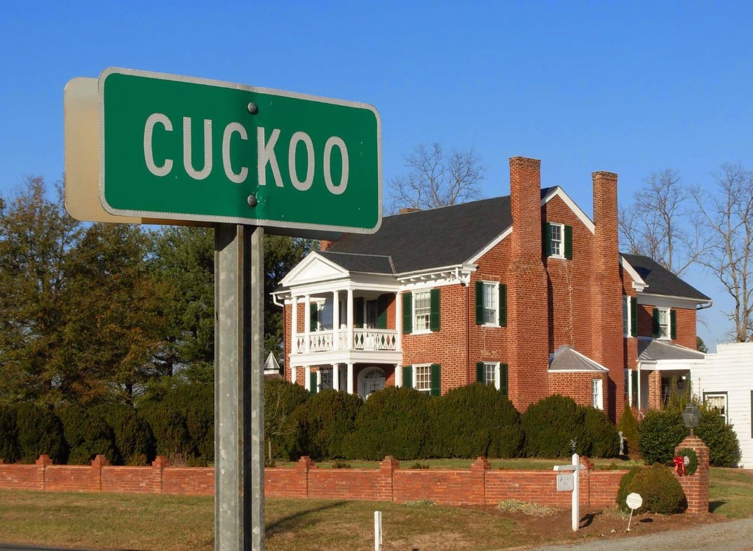
About two weeks ago, as I was rambling around western Goochland County and Fluvanna County between Rt. 250 and the James River, I came across several of these “named places.”  Here is one sign by the side of the road. There were a couple of houses around, but they did not seem associated with the sign. This one does not appear on the map.

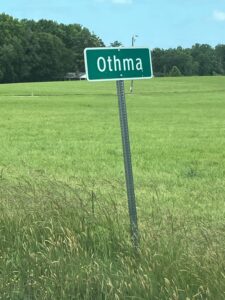
Apparently, this was the site of a two-room school by that name in Goochland in the early 20th century.

Here is another one that does not appear on the map. It was in the yard of what looked to be an older house that had been renovated.

Sources I consulted did not provide a source of the name, but if one Googles “Enon, Va. Goochland County.” Zillow will show you several houses and plots of land for sale in the Enon community.

This one does show up on the map. There is an intersection and a couple of houses. I have never seen one constructed like this. Apparently, someone wanted to be sure that travelers realized that “Fife” was comprised of the area in both directions.

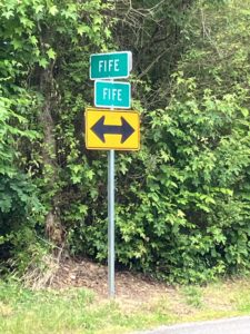
The community of Fife is still viable. There is a Fife Volunteer Fire and Rescue Company. Near this intersection stands the one surviving “Rosenwald” school built in Goochland County in the early 1900’s for Black students. (A foundation established by Julius Rosenwald, a wealthy Chicago businessman, was instrumental in establishing these schools all over the South.) The building looks much like it did when it was being used as a school and today is a museum operated by Goochland County.

The section of Rt. 6 along the James River from western Goochland through Fluvanna and into Albemarle County has several places of interest. Our Bacon’s Rebellion colleague, James Wyatt Whitehead, has often referred to Fork Union Military Academy. That private school is located on this route at, of course, Fork Union. The buildings are impressive:

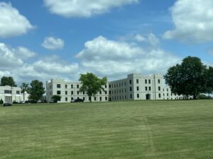
There definitely is little around here to distract the cadets from their studies.

The state highway map shows “Dixie” just before one gets to Fork Union. I somehow missed that sign. I will look for it when I am back in that area.

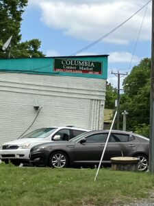
Traveling west, before one gets to Fork Union, there is Columbia. Here, Rt. 6 is close to the river and the railroad. Looming over the road is a high cliff and at road level is exposed granite that is about 450 million years old. The sides of the highway in this area are littered with dilapidated and crumbling buildings.  This building constitutes the only business here:

However, Fluvanna County informs the traveler that Columbia did have a notable past:

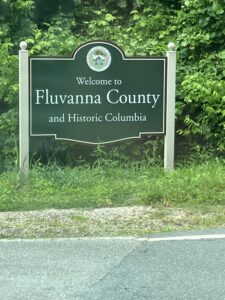
Columbia is situated at the confluence of the James and Rivanna Rivers. It was strategically important in the Commonwealth’s colonial times, first as a trading post on the western frontier and then as the location of the state’s chief arsenal during the Revolutionary War.

After the war, Columbia, chartered as a town in 1788, prospered as a shipping point on the James River for the tobacco trade and as an important terminal for the canals linking Richmond with Lynchburg and Charlottesville.

The opening of gold mines in Fluvanna County in the mid-1800’s brought more people to Columbia. At one time, the town had seven taverns, a sure sign of prosperity. There were also four churches, a bank, and profitable milling and ferry businesses. There is a legend that the town came within a few votes of being designated the capital of the state.

After the Civil War, the railroad brought tons of freight and hundreds of passengers through the town each year, enabling the town to prosper, even during the Depression. By the mid-1950’s, however, passenger and mail trains were no longer stopping in Columbia and freight trains slowly disappeared over the next decade.

What was key to Columbia’s early prosperity — the James River — also led to its downfall. Most of the town’s businesses and manufacturing facilities lay along River Road (Rt. 6) in the flat plain between the river and the steep granite cliff, the outcropping of which is visible along the side of the highway. The churches and many of the residences are higher up on the hill. Floods caused by Hurricane Camille (1969) and Hurricane Agnes (1972) pretty much destroyed the commercial part of the town and the town’s tax base. What survived those floods was finished off a few years later by Hurricane Juan (1985).

Like residents in other small declining towns, the people of Columbia did not give up easily. In 1990, they put the town up for sale. Actually, it was one absentee landlord who owned many of the buildings and lots in Columbia through inheritance, along with other property owners, who decided to market the town as a package deal. The asking price was $2 million. The hope was that the town would get designated as a National Historic District and a developer would build something along the lines of Williamsburg. Or, that some developers would want to get in on the ground floor as Richmond continued to expand westward. There were no takers.

In 2003, there was another spark of hope. The town, by then down to 50 residents, secured a federal $718,000 grant to begin rebuilding with the aim of becoming a historical tourist magnet for central Virginia. The money was used primarily to repair the town’s water distribution system, which tended to freeze in the winter, and to repair homes belonging to low- and middle-income residents.

Needless to say, that hope died, too. By 2015, the town budget was $4,000. There were 34 residents eligible to vote. In that year 19 of them voted in a referendum on whether to abolish the town and become an unincorporated part of Fluvanna County. The question passed on a vote of 18-1. The 2016 General Assembly obligingly enacted legislation revoking the town’s charter.

As you travel Virginia’s backroads, which I encourage you to do, remember that there are stories behind those place name markers you see along those roads.

Sources for history of Columbia:

https://www.washingtonpost.com/archive/lifestyle/1990/08/12/this-little-town-went-to-market/33dc70a4-4c2e-4d2f-9333-326625e18b01/

https://www.ourmidland.com/news/article/Virginia-River-Town-Seeks-New-Life-7085098.php

http://www.virginiaplaces.org/vacount/fluvanna.html


Share this article


ADVERTISEMENT

(comments below)


ADVERTISEMENT

(comments below)


Comments

56 responses to “Along the Back Roads –the Rise and Demise of a Town”

  1. Thomas Dixon Avatar
    Thomas Dixon

    The Dixie sign was likely removed because it, like so many other names in our history are intolerable to our newly designed woken future.

    1. James Wyatt Whitehead Avatar
      James Wyatt Whitehead

      My bet is the Dixie sign is hanging in somebody’s garage as a trophy or souvenir.

      1. WayneS Avatar

        You’re right on the money, sir.

        I live about a half mile from one of the Dixie signs. It gets stolen on a regular basis.

        1. Nancy Naive Avatar
          Nancy Naive

          What possible use could you have for more than one?

          1. WayneS Avatar

            There are supposed to be at least two. one on 15S and one on 6W. There might even be one on 15N/6E as you come towards it from Fork Union, I honestly don’t remember. In any even, at least one is almost always missing.

          2. Nancy Naive Avatar
            Nancy Naive

            No, no. I meant YOU. What possible use could YOU have? 😉

          3. WayneS Avatar

            Oh! I misunderstood. For me, one is enough…

          4. Lefty665 Avatar
            Lefty665

            Seeing as you designed the signage it is only fitting that you should have an example of your handiwork. In addition you may even have spec’d the size of the nut and bolt used to temporarily affix it to the pole.:)

          5. WayneS Avatar

            Oh, I only designed the county signage. The regular green “place name” signs are still VDOT’s. I’m sorry if I caused any confusion.

            My signs look something like this (which, to be clear is a joke, not a real sign):

            https://uploads.disquscdn.com/images/22bdf25de1e122dcc232f10aa4336cd123c82b0281bc7ced8c83ccdf2ceab4f0.jpg

            I came up with this sign after a resident called my office to complain about having a tick on them after visiting the nearly 900 acre, mostly wooded, Pleasant Grove Park. I never got around to making and posting an actual sign, but the grounds crew enjoyed it..

          6. Lefty665 Avatar
            Lefty665

            Very nice. People are amazing, and especially the come here’s from urban areas.

            Louisa’s County Manager had a bunch of stories. They included new residents complaining about the noise the cows on the farm next door made and another demanding County repairs because her sewage was backing up. His first qualifying question when he met someone was “what kind of tractor do you have?”

  2. Ronnie Chappell Avatar
    Ronnie Chappell

    Thanks for an interesting post.

  3. Great stories, Dick! Thanks for a welcome diversion from the usual Bacon’s Rebellion fare.

  4. Nancy Naive Avatar
    Nancy Naive

    “Short Lane” on Rte. 17 near Gloucester.

    Was a designated post office, then a gas station, a dry goods store… but NOW, ice cream! Homemade. Really homemade on site.

  5. Randy Huffman Avatar
    Randy Huffman

    enjoyed reading this, thank you.

  6. James Wyatt Whitehead Avatar
    James Wyatt Whitehead

    Yes there is a Cuckoo Virginia. Home of the Paul Revere of the South, Jack Jouett.
    https://uploads.disquscdn.com/images/54b69a71ca1b4515b823af508ad2797163e96150cbc65a03f72f3031470553ed.jpg

    1. WayneS Avatar

      Intersection of Rt 522 and Rt 33 in Louisa County, right?

      Just south of Mineral.

      1. Lefty665 Avatar
        Lefty665

        I was by Cuckoo the afternoon of the earthquake. There was significant damage and a couple of the chimneys were down. You can see in the photo the line by the upper window where the left one was rebuilt.

      2. Lefty665 Avatar
        Lefty665

        On Rt 618 roughly parallel to 33 and several miles north of Cuckoo running from Mineral to Bumpass are Dawn, Restawhile, Buckner and Bumpass itself where the road crosses the railroad track in ‘downtown’ Bumpass (locally pronounced bumpus in wisa county).

        Over near Scotchtown (aka Chiswell’s Folly) in Hanover county there is an intersection that when I moved to the Richmond area was named (Word no longer used by white folks) Foot on state maps. It was subsequently updated to Negro Foot and later dropped entirely. It is the spot where the leader of a slave rebellion was drawn and quartered and part of him left as a warning. The state hysterical marker notes the proximity of Scotchtown, Patrick Henry’s home during the Revolution. The killer intersection is now marked by a flashing light, the only light between Ashland and Louisa.

        Note: Norman Blake is from around Rising Fawn, Georgia. I had a friend from Devil’s Pond, Ga. Virginia is not alone with funny place names.

        1. James Wyatt Whitehead Avatar
          James Wyatt Whitehead

          I know where the community formerly known as Negro Foot is located. Weeza County is loaded with great local lore that only Virginia can produce. Spent a lot of time on the Lake near Peach Grove.

          1. Lefty665 Avatar
            Lefty665

            You were way up on the cold water side. That’s just starting to be a lake around there.

            My oldest boy went to 1st grade at Apple Grove, just down 522 from Cuckoo. Guess fruit trees were special in Wisa. They may not have had many other assets.

          2. James Wyatt Whitehead Avatar
            James Wyatt Whitehead

            I passed thru Apple Grove on Saturday. Unchanged. Love it!

          3. Lefty665 Avatar
            Lefty665

            I worked on a congressional campaign for a candidate who lived in Louisa. The manager and communications guys who were not local referred to Wisa as “The land time forgot”. They were obviously being pretty snarky, but in some ways there is virtue in not being too up to date.

        2. WayneS Avatar

          I have a friend who lives in Bumpass.

          1. Lefty665 Avatar
            Lefty665

            I was in suburban Bumpass, not far off 33.

  7. walter smith Avatar
    walter smith

    I grew up in the suburbs of Warsaw, where everything is back roads.
    When my kids went to Woodberry Forest, I would make the drive all back roads, going left then right and explored many different paths, my favorite being where the road ended at a stream and began about 15 yards later. I got out and walked through to make sure I could pass and continued. I think that was Rt 640, Jack Jouett Rd…
    As you go further West and North, lots of beauty. Rt 231 between Madison and Sperryville might be the prettiest, but I haven’t covered them all!
    Now can we get back to running down UVA (the Marxists in control, not the school)?

    1. WayneS Avatar

      Rt 231. I know that road well. It is incredibly fun on a motorcycle.

      That entire area was nearly destroyed by flooding on the Rapidan River that occurred about this time of year in 1995.

      A portion of Rt 29, including the the Rt 29S bridge over the Rapidan was washed away.

      Downstream from there, I think the river peaked at 29′ above normal in the little village of Rapidan.

  8. Stephen Haner Avatar
    Stephen Haner

    We do seek out that blue Virginia Byway sign when we can. Getting off the interstate when time allows is always the good choice. My favorites involve mountain views, not the flatland along the James. Once you get further west on 6, it gets prettier. 🙂 Having just been out toward Columbia last weekend, you failed to mention the big “industry” that is passed: all the Virginia Department of Corrections facilities!

    1. Nancy Naive Avatar
      Nancy Naive

      Hey! Eyes on the road. If you wanna look, pull off! Two lane blacktop is fun diving that hones the motoring skills, the least fun of which is avoiding cars where the driver is looking at the butterflies in the outfield. 😉

      1. WayneS Avatar

        100% agree.

      2. how_it_works Avatar
        how_it_works

        Dodging potholes (in dry and wet weather) and puddles of standing water (in wet weather) is also pretty fun, and Virginia’s 2-lane roads give you plenty of opportunity to do both.

        I looked at VDOT’s paving schedule map and their pavement condition map.

        I noticed that the portion of Poplar Rd (aka Pothole Rd) in Fauquier County that is ranked as having “poor” pavement condition is NOT scheduled to be repaved this year.

        The portion that is ranked “fair” or “good” pavement quality IS scheduled to be repaved this year.

        My parents aren’t closely related enough for me to have the sort of intellectual capacity to understand how this makes any sense.

        1. Nancy Naive Avatar
          Nancy Naive

          Vermont is tearing out the pavement and going back to gravel. Of course, they actually have a frost heave.

          The only reason for poor roads in Virginia is an insufficient roadbed.

          1. how_it_works Avatar
            how_it_works

            “The only reason for poor roads in Virginia is an insufficient roadbed.”

            Like painting over rotted wood…

        2. WayneS Avatar

          For the most part, the 2-lane back roads in Fluvanna and Goochland counties are quite well maintained.

          1. how_it_works Avatar
            how_it_works

            They all pretty much suck in PWC, Stafford, and Fauquier, unless they’ve been recently (within the last year or two) repaved.

            I think the repaving jobs on many of these 2-lane roads are about as effective as putting fresh paint on rotted wood.

          2. WayneS Avatar

            No, you are correct, those roads do suck.

          3. how_it_works Avatar
            how_it_works

            Probably because VDOT uses a “500 vpd” paving job on a “15,000 vpd” road.

            I noticed today how nice the pavement looks on Parkgate Drive…that part of which doesn’t get much traffic.

            The parts that do get a lot of traffic are bad. No potholes yet, but lots of cracking.

          4. Nancy Naive Avatar
            Nancy Naive

            There are only 3 reasons for roads to be in horrible shape;
            1) insufficient roadbed depth,
            2) untimely repairs of minor damage, and
            3) overweight trucks, usually dump trucks carrying twice their rated load tearing up one road while building another.

          5. how_it_works Avatar
            how_it_works

            I’ll add

            4)Poor drainage causing the roadbed to remain wet all the time. You’ll see roads that have new asphalt from about 5 feet from the edge to the inside, as though the outer half of the lane was repaved. I think this is caused by poor drainage.

          6. CJBova Avatar

            The other half of poor drainage is not maintaining drainage structures like crosspipes and driveway pipes and outfalls state road ditches are supposed to drain into.

          7. how_it_works Avatar
            how_it_works

            I never could find out if VDOT’s policy on crosspipes causing erosion is that it’s for the property owner to deal with, because I could never get anyone from VDOT to call me back. I ended up having someone line the ditch with recycled concrete.

            If anyone from VDOT is reading this and has a problem with that:

            Too bad. Do your job, which would’ve been to tell me that I couldn’t do that. Since you didn’t I assume you don’t care.

          8. CJBova Avatar

            VDOT’s Drainage Manual under Legal says:
            “Drainage Easements Acquired by the Department
            “The Department assumes maintenance responsibility within the limits of the
            drainage easement.”

            All state roads with ditches (not private or county roads) have deeded easements to VDOT. Crosspipes run from one side of the road to the other under the road. Pipes under driveways that connect ditch sections are VDOT’s responsibility after the initial installation.
            Call 1-800-FOR-ROAD and quote Code of Virginia 24VAC30-73-90.
            E. Maintenance of private entrances shall be by the owner of the entrance, except that VDOT shall maintain:

            1. On shoulder section highways, that portion of the entrance within the normal shoulder portion of the highway.

            2. On highways with ditches, the drainage pipe at the entrance.

            3. On highways with curb, gutter, and sidewalk belonging to VDOT, that portion of the entrance that extends to the back of the sidewalk. If a sidewalk is not present, that portion of the entrance that extends to the back of the curb line.

            4. On highways with curb, gutter, and sidewalk not belonging to VDOT, only to the flow line of the gutter pan.

            5. On highways with shoulders, ditches, and sidewalk belonging to VDOT, that portion of the entrance that extends to the back of the sidewalk.

          9. how_it_works Avatar
            how_it_works

            I’ve lived in Virginia long enough to know that the prevailing attitude is that “rules and regulations are meant to be ignored”.

            I’m sure that MAYBE if I got on VDOT’s case long and hard enough, I could have gotten them to what they’re supposed to do with regards to that erosion problem…

            …but in the end it was just easier to pay someone to fix it.

      3. Lefty665 Avatar
        Lefty665

        You get used to rural 2 laners after living in the country for awhile. The older ones with narrower right of way can be interesting as locals know where they are going and tend to step right along.

        Where I am now the biggest hazards are gangs of bicyclists coming out of Richmond on weekends. They don’t understand that the twisty hilly roads with no shoulders they are enjoying are mortal hazards to them. Pop a hill or a bend moving quickly with something coming the other direction and a gaggle of cyclists in between and it’s mayhem time. Spandex is not a good cushion.

      4. Lefty665 Avatar
        Lefty665

        You get used to rural 2 laners after living in the country for awhile. The older ones with narrower right of way can be interesting as locals know where they are going and tend to step right along.

        Where I am now the biggest hazards are gangs of bicyclists coming out of Richmond on weekends. They don’t understand that the twisty hilly roads with no shoulders they are enjoying are mortal hazards to them and they’re not really in the Tour de France. Pop a hill or a bend moving quickly with something coming the other direction and a gaggle of cyclists in between and it’s mayhem time. Spandex is not a protective garment.

  9. DJRippert Avatar
    DJRippert

    For those of you on Facebook, there is a group called “Abandoned in Virginia” that has lots and lots of photos of abandoned structures throughout the state. As you’d expect, most are in rural areas since the value of the land under abandoned structures in urban and suburban areas usually means that the abandoned structure is quickly demolished.

    1. how_it_works Avatar
      how_it_works

      Usually, but this has been rotting on VA 234 Business in Manassas since before 2008:

      https://uploads.disquscdn.com/images/fb8871d2748b1d31564912103ff72111c0494064e6ac77fd4d9a477f131e0293.png

  10. DJRippert Avatar
    DJRippert

    I love country stores. I don’t know why. When I go trout fishing in Nelson County I drive my fishing buddies nuts when I have to stop and go into every country store along the way.

  11. WayneS Avatar

    There is also a Rosenwald School in Fork Union, known as the Dunbar school. It is privately owned and operated. It was restored as a labor of love by it’s owner, Ms. Carmen Smith using her own funds and donations.

    http://fluvannareview.com/2018/07/kids-learn-stem-at-dunbar-schoolhouse/

    RE: Columbia – The rundown buildings in the first two photos at the virginiaplaces.org link are gone. The larger one was demolished last year, and the orange colored one was removed in about 2017.

    Legend has it that at some point in the late 1700s Columbia came within a few votes of becoming the state capital. (Oops. That’s already in the article).

    Thanks for highlighting some of the things located in my neck of the woods. I drive/ride through Columbia just about every day. If you love back roads, try Stage Junction Road running north out of Columbia the next time you’re out this way. It becomes Wilmington Road, and then if you turn left on Courthouse Road in Wilmington (another sign without a town) you’ll end up in Palmyra.

    CORRECTED 12:16 06/13/2023

    PS – I designed the Fluvanna signs (like the green one in your picture). Or, more accurately, I significantly modified and updated a design started by someone else. From 2012-2018 I was the Director of Public Works for Fluvanna County.

    Oh, and next time you come to Fluvanna, I highly recommend you visit Pleasant Grove Park and the historic Pleasant Grove house. The historic courthouse in Palmyra is also worth seeing.

    1. Dick Hall-Sizemore Avatar
      Dick Hall-Sizemore

      Thanks for the tips. I did not realize that I was in your neck of the woods.

      1. WayneS Avatar

        We’ve lived out that way for about 10 years. Before that it was Rixeyville (another sign without a town) in Culpeper County for 23 years.

        1. Lefty665 Avatar
          Lefty665

          I had a friend who was a Kent, ex of Kent’s store. He had relatives in Columbia too. Looks like you’re about half way between my kid in Batesville and me, but I’m not sure you can get there from here:)

          Years ago I hung out with the County Administrator in Louisa. It looked to me that rural local government was pretty good, but without the resources to do much. OTOH, they couldn’t do too much either.

  12. WayneS Avatar

    The Rosenwald school in Goochland is on Hadensville-Fife Road next to the Second Union Church.

    https://secondunionrosenwaldschool.org/

  13. Paul Sweet Avatar
    Paul Sweet

    Don’t forget Frog Level – one in Caroline County and one in Tazewell County.

    The one in Tazewell County is where Va. Rt. 16 and U.S. Rt. 19 intersect. It has a general store, which looked abandoned a few years ago, and a few houses. Va. Rt. 16 between Marion and Tazewell is called the Back of the Dragon, and is one of Virginia’s greatest back roads.

    Southwest Virginia has many great back roads and Byways.

    1. Dick Hall-Sizemore Avatar
      Dick Hall-Sizemore

      I have driven that road between Marion and Tazewell and, yes, it is a great back road. I did not know that it was called Back of the Dragon.

    2. James Wyatt Whitehead Avatar
      James Wyatt Whitehead

      The volunteer fire department at Frog Level on Rt 2 in Caroline. They changed my busted water pump on the old Chevy Celebrity back in 1989. I gave the department a hundred bucks later. I had no cash on me at the moment. They took mercy on me. Paid for the parts and all. But that was a different time and a different Virginia.

Leave a Reply